
The name of the first white man to visit the upper valley of the West Fork of the Monongahela is enshrouded in mystery. Tradition associates it with the name of one Jacob Bush. Again it is connected with the alleged visit of the "Three Frenchmen", connected by legend with Braddock's defeat, who fled through Upshur into this region, to bury British gold in the vicinity of the mouth of Canoe Run. But to John Hacker, the first settler in Lewis County, belongs the first recorded visit that of a hunt into the headwaters section which resulted in the naming of several streams.
Following Hacker, in 1792, came the noted border scout, Jesse Hughes, who with a companion, entered the valley from the French Creek region, on an Indian scout. Out of his visit emerged the name Canoe Run and Indian Fork, as well as others. As the outgrowth of these expeditions, Colonel George Jackson became interested in the region. In the course of time Collin's settlement evolved; a post office was established by 1821, and the community name in common use today was adopted. But all covering more territory than can herein be considered.
John P. Duvall, later mentioned, claims the honor of the first "improvement" near the present site Roanoke, having made a "settlement" in 1775 at the Indian House or Arnold Station. This possibly existed on paper only. He later assigned this to Samuel McIntire, who sold it back later. Duvall secured 800 acres in all, and 400 as assignee of Robert Burchett, near the mouth of Sand Fork.
In 1785, James Anderson and Samuel Hanway, secured 1000 acres in the valley below Canoe Run. It ran in a square, taking in roughly the land to Rush Run hill. In the same year John P. Duvall patented 400 acres, which included the site of Roanoke. In 1786 for "two pounds sterling" he secured 1400 acres more embracing the land between Roanoke and Arnold and a large part of Canoe Run. Duvall was a prominent man in frontier days and his "Indian House" was the site of an old Indian village, it seems. The writer has a collection of flint implements secured in this vicinity. John H. Conrad has a similar collection from the lower valley, and for years on the farm of the late George Cook could be discerned a small mound attributed to a race here before the Indians. John Sprigg of Maryland took up lands on Sand Fork in 1818; David Smith likewise; and in 1846 M. G. Bush patented 100 acres on the same stream. Michael Waybright followed with 1000 acres embracing Wards Run. On White Oak Lick Jackson Arnold took up lands; Skelton Smith and several others also secured state lands, (which cannot be considered extensively here.)
The first settlers in the immediate vicinity of the village of Roanoke, located on the Anderson and Hanway tract of land, covered by a survey dated July 7, 1785. The first permanent settler was "John Mitchel", to whom Samuel Hanway, a resident of Monongalia County, on September 9, 1812, for the consideration of "One Hundred and Twenty-five Dollars, lawful money of the Virginia, "transferred all of a certain tract granted to James Anderson and the said Samuel Hanway for one thousand acres". "It is further understood that he, the said Samuel Hanway only sells and releases such titles as he has in the aforesaid tract of land, and does not undertake to support the title for the same". This deed was produced in court in April, 1813, and ordered recorded.
According to local tradition, John Mitchell had come from lower Harrison County to this region as early as 1808, with his family, among whom was a son Abner. The latter as early as 1814 had established a home a short distance above the mouth of White Oak Lick, and in 1820 the county court of Lewis County decreed that a road should be located by his place to the ford at Henry Camden's (now Jacksonville). This road was declared a public highway in 1832, but in reality was little more that a bridle path for some years later.
In 1839 an order was entered by the county court directing that Abner Mitchell erect a bridge at the mouth of Canoe Run, to replace the ford at that point. About 1830 he established a saw mill near his home which was in use until 1840. In that year, - with the exception of 1861, - the upper valley was visited by the most disastrous flood in its history and the mill was washed away. Elan and Peter Mitchell, sons of Abner, became local ministers of the Methodist Protestant faith.
On October 7, 1813, William Hacker and "James Teeth" received a grant of 215 acres lying "on both sides of the West Fork and both sides of Canoe Run". This included the bottom lands at the mouth of Canoe Run and extended almost to the mouth of White Oak Lick on the south bank of the river. The first permanent settler on this tract is said to have been Jonathan Wheeler, in or about the year 1830. He secured part of a later grant to George J. Arnold, dated February 16, 1844, and this tract was transferred in 1855 to John L. Prince. In 1860 it was sold to Richard Watson, and later became part of the holdings of Erasmus Rhodes. James and Henry McCally located near the mouth of White Oak Lick prior to 1844.
Richard Bond, about 1825, located just below the site of the Seventh Day Baptist Church. He was born in Harrison County, February 16, 1814, and died February 11, 1871. He married (1) Lydia M. Davis, a sister of "Uncle" Samuel Davis and (2) Ann Elizabeth Crowl. A son, John, was one of the early land owners on Canoe Run. The land books for 1848-9 charge him with one tithable, "2 hosses at 10›", a "wood clock at 13›", 197 acres of land on "crooked Run of West Fork" and "road tax on same as revenue $1.32" in all totaling $3.59. Such was taxation in that early day under old Virginia.
In 1838 Abraham Rohrbough located across the river in the shadow of the hill that has since borne the name of "Abrams Knob". He was born in what is now Upshur County, in 1815, a son of Anthony Rohrbough, one of the early pioneers. Two sons, Anthony E., and John G. served through the Civil War in Company B, 15 West Virginia infantry.
On the bottom lands below the Rohrbough's located John and William Godfrey, brothers, from Hardy County and connected by marriage with George T. Duvall of Indian Carrying Run. John Godfrey was born in 1796 and died in 1863 and is buried in the old Mitchell cemetery, along with a number of pioneers who repose in unmarked graves. The Godfreys combined noted hunting exploits with those equally as renowned in rafting logs on the old West Fork. Tradition credits one with having erected his "cabin" at the mouth of Sand Fork.
William Rohrbough located just above the mouth of Canoe Run in the early forties and about 1845 built a log house still standing by the roadside between the mouth of this stream and the village of Roanoke.
In the late thirties Jacob Hevener, of what is now Highland County, but then residing at Mingo Flats, Randolph County, became interested in the Anderson-Hanway survey. Amos Hevener located on that portion later embraced in the Rhodes land, erecting his home on the rising ground on the south side of the river. He was born in 1817 and married Arista, daughter of Benjamin Lightburn, and sister of General J. A. J. Lightburn. After residing here for three or four years the family removed to Randolph County.
A year or so later Reuben Hevener, a cousin to Amos, located nearby. He married (1) Elizabeth Eye, (2) Catherine Snyder of Monterey, and (3) Abagail H. Davis and they were the founders of the family now residing in this community. Some intermarried with the Bond, Bird and other local families, and acquired portions of the Richard Bond and other lands on Crooked Run.
In 1852, the settlers were augmented by the arrival of Erasmus Rhodes, who was born in Melrose, Rockingham County, Virginia, February 26, 1826. In the spring of 1849 he joined the exodus of folks from the Valley of Virginia, to the famed gold fields of California. Returning to the East about 1851, he married Elizabeth Hevener, daughter of Jacob Jr., who was born in what is now Highland County, Virginia, in 1830, and died in 1866. He acquired the main portion of the Hevener holdings in the Anderson-Hanway tract; this was increased in 1859 by additions from the Arnold lands on Wild Cat and Sycamore Run and the Watson tract before mentioned, until a boundary of 1200 acres was secured which embraced portions of White Oak Lick, Carrion Run, and others named. With the exception of the Arnold and Bennett holdings. This embraced the largest homestead in Collins Settlement district. The old manor house erected in the early fifties on the rising ground a short distance below the present residence thereon was destroyed by fire in 1868.
In keeping with the tendencies of settlers from the Valley of Virginia he established here the largest orchard in this section which was destroyed during the raids in the Civil War, while the owner was absent in the service. He served in cavalry command of Brigadier General William L. Jackson (Confederate) and owned "Selin" a noted cavalry horse. In 1867 he married Mary Catherine, daughter of George Conrad, Sr. He died August 3, 1900, commanding the respect and esteem of all who knew him.
A survey of the Hanway and Anderson tract in 1864 shows the following owners: Jacob Hevener, John Godfrey, Richard Bond, Paul T. Mitchell, Abraham, William and George Rohrbough. The last named transferred his land to Reuben Hevener, and it is now owned by Mansfield and John J. Hevener. The last named is now the oldest resident of the community being 88 and has been for years very active in horticultural matters, as well as active in musical circles. Likewise it is worthy of passing note that he brought into the community the first organ, the first phonograph, and in 1923 installed the first radio set.
About 1868 James Madison Corley, later State Senator and member of the "registration board of '67" located below the Bonds, and established a hotel at the Wilson Place. Part of this property was sold to H. C. Ramsey of Monongalia County in 1880. In 1918 the greater portion of the original survey was owned by the Erasmus Rhodes heirs, Bond Heirs, John McCray, William Wilson, H. C. Ramsey, Mitchell Heirs, and Snyders.
About 1825 Michael Bush acquired the 400 acre land grant issued to J. P. Duvall in 1785, upon which he established his home and erected a mill as will be noted elsewhere. In later years he took steps to acquire adjoining property lying north in the Canoe Run Valley. On December 30, 1842 he received a grant of 110 acres on the "waters of the West Fork and Canoe Run, based on a survey made on June 16, 1842". This began as a corner on Canoe Run just above the "Quiet Dell School House" and extended to a corner of a "survey made in the name of John P. Duvall and now owned by said Bush" and thence to a point "near said Bush's spring on said Duvall's survey" and following a line to survey in the name of "William Hacker and James Teeth". The southern line was about half way up the hill in the rear of the "old" Joseph Hall home above Roanoke, and the "said Bush's spring" was located in the rear of this location then occupied by the home of W. G. Bush. On this hillside was located "Margaret's Chapel", a one story log building in which circuit riders of the M. P. Church held services in early years. Definite church records seem to be lacking but it is related that Rev. Samuel Clawson, widely known as the "Wild Preacher" and whose name is preserved in the Clawson-Helmick Memorial church in Weston, often held services here. Nearby is an old cemetery in which several members of the Bush, Long, and other families lie in unmarked graves.
The largest and most important land grant in the lower Collins Settlement district was one to William E. and George Jackson Arnold, dated December 31, 1844, and based on a survey made on June 6 of the same year. This marked the passing of the last of the large boundaries of state lands in this region. A survey of the condition of the county elsewhere at this time, would at this day cause a wonderment as to why this had so long remained unpatented, yet down until long after the Civil War much of this section was still in timberland. It would have, perhaps, been more so, had not a few men assumed an aggressive campaign to secure permanent settlers thereon. It is true some settlements had been made but by folks who found it cheaper to move than own their own land.
The Arnold grant covered a boundary of 2800 acres "on Canoe Run waters and Carren Run waters of the West Fork adjoining on the West side of surveys made for Anderson, Hanway, Michael G. Bush, and John P. Duvall". This included practically all of the Carrion Run valley, the right and middle forks of Canoe Run and portions of the main valley, comprising a section in a fan shape. In the meantime possession had been acquired of a considerable portion of the Keith and Hacker survey which gave an outlet to the entire Canoe Run valley.
On the Court House district side this patent was joined by the Pickering survey, which was the cause of a great deal of trouble over line titles. This survey comprising in the main body 20,000 acres was made in 1785 for Timothy Pickering, who was born in 1745 and died in 1829. He was an officer in the Revolution and occupied almost every public office in the command of the nation. It was one of the few "land Bonus" grants for service that touched Lewis County. Upon his death it passed to his son Octavius Pickering, and as one early barrister sets forth this patent and others of this family "was patented, granted, and litigated to death". Another patent of 5,000 acres also adjoined it.
On November 12, 1849, Octavius Pickering (1791-1868) assigned his claims to Gideon D. and Richard P. Camden and Minter Bailey. It was resurveyed and by 1845 a couple of small tracts were sold. Other claimants now came forward and considerable trouble was incurred during the next fourteen years, to such an extent that the new owners appealed to the Virginia Assembly for relief. That body accordingly on February 23, 1854, directed, - provided they signed certain papers, - that the Virginia Land Office issue a new grant formally investing in Camden-Bailey-Camden a good and sufficient title.
As late as 1867 an engineering party came to Bush's Mill, acting under alleged claims to the Pickering lands and after surveying a portion of the Canoe Run valley at the head of the right fork a point on the Arnold survey was located and a line run north. A few marked trees were found but the attempt was abandoned.
The first settler on the Arnold patent appears to have been Isaac Rohrbough, a son of George S., who located in the county in 1823. He established his home on Carrion Run in 1846 and in later years became one of the first school commissioners.
The next family was that of Christian (died in 1865) and Hannah Swecker. They were of Holland Dutch descent and had in early years moved from what is now Highland County, Virginia, to Valley Head on the Tygarts Valley River. In 1844 they located on the Rhodes place, then the home of the Heveners. In 1847 title was acquired to 280 acres of the Arnold grant on the right hand fork of Canoe Run and they became the first permanent settlers on this stream. They had several children among whom was Manley who enlisted at the age of 19 in Company B, 15th West Virginia Infantry and served through the Civil War.
Soon thereafter George W. Cook located just below Swecker's on the same branch on 200 acres acquired August 31, 1851. He was a son of Captain John Cook, of Staunton, Virginia, and in whose home was held the first county court of Highland County. He was born in Monterey, Virginia, June 26, 1826, and died August 23, 1900. Two of his children were prominently identified with educational matters following the close of the Civil War.
Owen Mullooly, who was born in Roscommon County, Ireland, in 1823, became the forerunner of the Irish settlers, acquiring 275 acres on the head of the middle fork in 1851.
Valentine Bird in 1852 located below George Cook, and on April 10, 1855, George Conrad, Sr. acquired 279 acres embracing the mouth of Canoe Run and became the first permanent settler at this point.
Of the first settlers on Canoe Run much exists only in tradition. One William Collins, of the noted Collins brothers, is said to have been the first, and there is said to be some connection with unmarked graves located on the hillside along the roadway between Roanoke and the mouth of Canoe Run. Other stories connect them with the family of one Thomas Roby, who about 1825, located a short distance above the mouth along the right hand side of the road as now located. The well at this place was surrounded by the first apple trees on the stream which existed long after the cabin had disappeared.
Above Roby's settled a family by the name of Bush, and also Gum Long. A family by the name of McCord located near the forks. On the right hand fork lived James McLaughlin, James Watson, William Murphy, and Alfred Posey. On the main stream above settled Charles Post, and a family of Smiths located at the mouth of Middle Fork. On this branch lived Jessee Garrett, Michael Kelly, Hohn Gaphegan, "Paddy" Morgan, John Conner, and Zechariah Curtis. The last named is worthy of more than passing notice, as he lived nearly all his life in this section, some ninety years. He was one of the most unique characters of that early day, the time when "evil spirits and witchcraft" were still believed in by the superstitious. He belonged to that class of persons of his time, and they were numerous, who never acquired title to any land, preferring to "squat" where the hunting and fishing was good, raise a little corn, and dig a little "seng.". A large family was raised, among whom were "John, Seliathiel, George, Louis, and "Aunt Betsey Harris" all of whom were among the last connecting links of the present day with the days of the first settler.
At the head of the main stream the first settlers were James Kieth, Jr., and Oliver Forinash. In 1853 Captain J. C. Wilkinson located on the Middle Fork. He raised a large family and was prominently identified with Civil War matters. Michael McDonnell, John A. Griff, John Feely, Michael and Bridget Grady Rush, of Roscommon County, Ireland, followed soon after, the latter family giving the name to "Rush Knob." Charles Morrison located about 1858 on the right fork and J. P. Conrad just above the mouth at the Post place in 1859. William and "Trav" Atkinson located on the Arnold lands at the extreme head of the main stream, and south of them Decker Morrison built a big log house in what was called "Jack Hollow".
At the mouth of Middle Fork, John C. Bond, a son of Richard, located in 1865. He married Elizabeth Schiefer and a son A. J. C. Bond had been very prominent in the annals of the Seventh Day Baptist Church. This property marked the northern boundary of the J. P. Duvall 1400 acre survey, part of which passed to I. C. Waldo, Sr. The stream above this to the site of the Allman homestead was a virgin forest, and only a trail that led over the hill to the old Bush Mill from this point, served as a road. It was long known as the "Waldo Road". Much of the land on the main fork above in 1871 passed into the hands of S. B. Mullins and Margaret Bird Cook. George W. Conrad located below the Right Fork in 1866, and John R. King at the head of the Middle Fork in 1868. James F. Conrad established his home at the mouth of the stream in the same year.
John R. King was born near Fairmont, April 8, 1842. He was the son of William and Roanna Cooper King, early settlers in Marion and Upshur counties, and a grandson of Joshua Hedges King, and early settler in Prince Williams County Virginia, and who was a close friend of George Washington. In company with a brother Cyrus B. he enlisted in Company B, 25th Virginia Infantry under Captain E. D. Camden, at Warm Springs, Virginia May 17, 1863. In this division, called "The Upshur Greys", he saw some of the heaviest fighting in the Shenandoah Valley and at Gettysburg. He was made a prisoner at the Bloody Angle at Spottsylvania Court House in an engagement during which Captain Camden was left on the field for dead but finally turned up as a member of the "Immortal 600". He was discharged June 14, 1865. During the last few years he had been a contributor of a series of articles depicting early life in the Monongahela Valley and is also author of "My Experience in the Confederate Army" published in Clarksburg, in 1916.
The beginning of the Seventh Day Baptist Church dates back to meetings held at intermittent periods at the homes of Richard Bond and Ruben Hevener. At the close of the Civil War enough local support existed to erect the building still standing on the brow of the hill below Canoe Run. It was dedicated January 19, 1872.
The first school in the vicinity conducted under the old Virginia school system was taught in a log cabin that stood opposite the mouth of Canoe Run. In it a few sessions were held prior to 1858, after which the Union Meeting House was used, and in which was held the first school under the West Virginia system in 1863 with Americus Groves as teacher. The names of Bird Jodon and Ella Hall also appear among the early teachers. In 1867 a school was established at the forks of Canoe Run with M. M .Eaton as teacher, who was followed by George Cook. On White Oak Lick the first school was conducted in 1872 by Hon. W. W. Brannon. He later was connected with the Weston schools under Edward S. Bland and Dr. Loyal Young, finally leaving this occupation to take up the practice of law.
Tradition relates that one Robert Burchett was the first settler on this stream, locating near the mouth on the "first bottom lands". Aquila Robey, a noted hunter located on a branch since called Aquila Run, about 1815. He was a native of Highland County (Augusta) Virginia, and had married (1) Margaret Meeker in 1795 and (2) Catherine Cunningham in 1799.
Samuel Wilson, a neighbor of the Robey's in Virginia, who had married Jane Armstrong in 1819, settled on a branch since called Sammy's Run. He died some time prior to 1847 during which year a patent was issued to his heirs. In 1822 Thomas Armstrong, from the same section of Virginia located on the main stream. He was born in 1799 and married Sarah Pullin, member of a family, several members of which located in Lewis County around Arnold and on the waters of Oil Creek.
David Smith, in 1818, located adjoining the Duvall lands at the mouth of the stream. Michael Waybright, of Highland County, Virginia, located on the site of the J. B. Watson home. He married Susanna McCartney in 1808, a member of the McCartney family that located in later years near the forks of the river. Benona Powers follows soon thereafter and settled on what has since been called Wards Run. Here he furnished a site, made by the hand the lumber, and erected the structure long known as Powers' Church and now Marvin's Chapel of the M. E. Church, South.
William Gibson, John Wilson, Joseph and Robert McCray, James Brady, and Henry McCauley (McCally) followed soon after the Powers' family. John F. and James Watson from Fluvanna County, Virginia, located along the main stream about 1837. Robert Ervine, or Irvine, a native of Bedford County, England, located about 1840. He married a Matheny, member of an early family in Highland County, some of whom located near present Walkersville.
Louis Swisher, John Linger, and H. B. Wetzel, of Shenandoah County, Virginia, were the next settlers. Rev. George I. Marsh, an early M. P. minister and John J. Marsh located a short distance above the mouth of the stream. By 1847 little if any State lands were left unclaimed and the entire Sand Fork valley was fairly well settled. Albert Jewell, a school teacher from Maine, acquired the Louis Swisher lands about 1856. This later was owned by W. L. Smith and in 1919 possession passed to W. R. Jewell and I. G. Hornor. Manuel Whitesell and John Hargrove at an early date took up their residence about two miles above the junction of the stream with the West Fork River.
The beginning of the village of Roanoke, now embracing some 132 persons, antedates the existence of the name for many years dating back to about 1825. At that time the Mitchell's below present Roanoke and Duvall's at the Indian Carrying Place (Arnold) were practically the only settlers between the mouth of Skin Creek and the ford at Henry Camden's now Jacksonville, of whom any definite record exists. It is related, and perhaps with some degree of truth, that one John Smith located on the Duvall lands a mile or so above present Roanoke, about 1820. He started to build or did build a dam in the river near by and traces of it stood as evidence for many years. About 1824 Henry McCauley erected a log residence just below the mouth of Sand Fork, just below the present residence of R. W. Duncan. William A. Watson, about 1850, removed this structure to the present property of Charles W. Watson. David Smith located a short distance above in 1830.
In 1825 Michael G. Bush, then residing on Skin Creek acquired from J. P. of Lewis L. Duvall, the 400 acres patented by the former in 1786, which included the site of Roanoke. He as before stated, made subsequent acquisitions which made him a large land holder in the community.
In the records in the Circuit Clerk's Office, and part of the Court of Law and Equity, reposes an old and faded document which marks the beginning of the most historic mill in the entire settlement. To it is attached the signatures of several of the earliest pioneers in this section, the Bennetts, Kieths, Duvalls, McCauleys or McCallys, Spriggs, and others.
This "writ of adquodamnum" was executed on the 30th day of July, 1825, and is marked "inquest herewith returned according to law. I. F. Newlon, D. S. for Thomas Cunningham S. L. C. 1825." It reads as follows:
The Commonwealth of Virginia to the Sheriff of Lewis County, Greeting,- you are hereby commanded to summon and empanel a jury of 12 discreet and intelligent freeholders of the said county to meet on the land of Michael G. Bush, at the place where the said Bush proposes to abut a dam on the West Fork River to work a water grist mill, on the last Saturday in this present month, and then and there to condemn according to law a site for the said mill to be built by the said Michael Bush. And the freeholders so taken by you shall be by you charged impartial and to the best of their skill and judgment to view and examine the lands above and below the said mill seat. The property of others which may probably be overflowed and say to what damage it will be to the several proprietors, and whether the mansion house of any such proprietors or the offices, garden or orchards, immediately belonging to any such proprietors will be overflown. To inquire whether and in what degree the passage of fish and ordinary navigation will be obstructed, and whether and by what means such obstruction may be prevented, and whether in their opinion the health of the neighbors will be damaged by the stagnation of the waters and that they also acquire what damages it will be to build said dam eight feed high from low water mark, and also to whom the bed of the river belongs, which request so made shall be by you sealed and returned to Court on the first Tuesday in August next, according together with this writ.
WITNESS Daniel Stringer, Clerk of our said Court at Weston, this 22nd day of July, 1825, and in the fiftieth year of the Commonwealth.
D. Stringer."
"In pursuance of the above writ of ad quo damnum we the subscribers freeholders of Lewis County having been duly summoned and have taken the oath subscribed by law. Having proceeded to view the land proposed by Michael Bush for an abutment by which to work a water grist mill and have condemned according to law the said site. Also have examined the land above and below and find the improved land to be worth Four Dollars per acre (the property of others) which may overflow. We further find that by executing a dam eight feet high from the low water mark, the houses, etc. referred to in this writ will not be injured therefrom, more than above mentioned. We also find that the passage of fish and ordinary navigation will be obstructed by erecting said dam but may be prevented by building a stope according to law. We further find that in our opinions that the health of the neighbors will not be annoyed by the stagnation of the water. We further find that the bed of the river belong to said Bush.
Given under our hands and seals this the 30th day of July, 1825.
| Hannibal Pugh David Bennett George S. Duval |
George Fisher Joseph Bennett Manuel Keith |
John West Joseph Flesher William Bennett |
John Sprigg Alexander Hacker Henry McCally |
Jonathan Hacker |
Within a very short time after the issuance of this writ the construction of the dam and mill was begun. When completed it was a large hewn log structure, on the turnpike side of the river, with a huge overshot wheel that exceeded any in size in the entire county. In addition to being able to take care of the needs for food, it had machinery with which to saw lumber as well. About 1830, the home of M. G. Bush was erected on the site of the home of the late Joseph Hall, just above the village of Roanoke. It was a better and more pretentious structure than the average one of that time, and in it was held under his care the first school in the nearby section, and a few years later he taught a term or two in a log cabin that stood almost opposite the mouth of Canoe Run. The building had entirely disappeared.
In addition to the duties of Miller, Bush became the first merchant in this location, and had extensive dealings in such live stock as the community afforded in that early day, as well as filled the office of deputy sheriff under Jacob Lorentz. Nineteen years elapsed after the establishment of the post office at Collins Settlement before the number of settlers justified one farther down the river.
On December 21, 1840, the post office of Bush's Mill was created with Michael Bush as postmaster, and he continued to execute the duties of this office until November 27, 1849, when William Rohrbough was appointed his successor, and the office was moved to the home of the latter near the mouth of Canoe Run.
On April 30, 1845, Mary Ann Duvall Maddox, and children conveyed to Isaac C. Waldo for the consideration of $475.00 a tract of land containing 280 acres, it being a part of a tract of land containing 900 acres deeded by the late Lewis Duvall to his heirs and that part of the tract in which the division fell to the said Mary Ann first above named. Upon this tract Isaac C. Waldo, Sr. became a settler establishing his home along the turnpike a short distance above the old Bush mill. The land adjoining below was transferred to Mary Elizabeth Arnold (Mrs. Joseph Hall) daughter of Elijah and Prudence Jackson Arnold.
On October 2, 1845, for the consideration of $700.00 Michael G. Bush and Ameilia, his wife, transferred to Isaac Waldo "a certain piece of land lying and being in the county of Lewis on the west fork of the Monongahela river including the mill belonging to said Bush containing two acres and 129 poles."
This marked the passing of Bush's Mill so far as application of the name to the mill was concerned. In the succeeding years it was known as Waldo's mill although the post office continued to be called by the former name.
In the spring of 1861 occurred the worst flood this region has ever known, the mill race was cut through by the water making a small channel on the road side of the building which in succeeding years became larger. The mill building - which stood a short distance above the "Hall Place" - stood on the bottom land between the river and the Weston and Gauley Pike. In the course of time the inroads of the water had so shifted the river bed that the mill stood on a small island and a gang plank had to be used to secure success. Below the entrance the race cut a great deep hole that was the rendevous of the youth for miles around. A big spring board was fastened to the gang plank and it became the community swimming pool. Some of the machinery was damaged by Imboden's men during the raid into the county during the Civil War, and by the close of the war family adversities and local conditions had almost closed active operation of the mill.
The river kept making inroads until the bed moved some hundred feet or more, and in the early seventies the structure began to settle in the river bed, and was gradually washed away by succeeding floods. It is now only recalled by traces of the dam site and an occasionally decaying timber unearthed by the "Old West Fork.."
"By a giant old oak at the foot of the shoals,
Stood a quaint old mill where the water rolls,
'Twas part of the scene with the trees and cliffs,
And the water wheel and the miller's skiff.
But the mill grew old, and the old wheel shook,
The slanting roof took on a battered look,
And the passing years with their days of flood
Leave only a memory of where it stood.
How the old oak stands like a sentinel gray,
To mark the spot where the old mill lay,
The cliff is there, and the house along the hill,
And fond recollection lingers round it still."
- Sam Badger. -
In later years the location has long been known as "Mussel Shoals" the name being derived from the numerous shell fish of this variety to be found there. The writer has in his possession a pin set with some 25 baroque pearls derived from this source.
Isaac Waldo, Sr., the owner of the Bush-Waldo mill, was born April 21, 1818. About 1836 he married Elizabeth Goff, a niece of Colonel Waldo and Nathan Goff of Harrison County, who was born in 1817 and died at Roanoke, February 22, 1900. Prior to her marriage and for a short time thereafter she had achieved considerable prominence as a teacher in such school systems as that early day afforded. A number of contracts yet in existence set forth that for so many months she is to teach "reading, writing and arithmetic so far as the single rule of three", her pay to be in "rye, wheat, and corn" and the pupils to "due obedience pay."
To this union were born four sons and no family suffered more adversities. Jedidiah G. born September 5, 1837, served as a lieutenant-captain and for a time was acting quartermaster in the Federal Army and died in the service at Washington, D. C. April 28, 1864. Thaddeus P. born in 1840 served as a captain in the Confederate Army. He resigned at the end of three and a half years to return home to assist at the mill, only to meet a tragic death in 1867 by being hit in the head with a bar while repairing the mill wheel. Isaac Jr. born in 1844 was a quartermaster in the Confederate Army and for a time attached to Company C. 17th Virginia Calvary. At the close of the war he married Betty Camp, and for some years afterwards operated the Arnold Hotels on the Weston and Gauley pike. Goff William, the youngest son, born in 1847, was drowned in the well at the old home place in 1850. The founder of the family was himself killed by a fall of slate December 11, 1846, in a coal mine owned by the family, located in the river bed in the site of the village of Roanoke.
| In 1852 Joseph Hall established a store near his home, and on June 16, 1854, was appointed postmaster, continuing for some eight years. On June 17, 1862, he was succeeded by George Conrad, who had located just above the mouth of Canoe Run in 1855. Here in a building much the worse now for the wear and tear of three quarters of a century, it was conducted for some twelve years. | 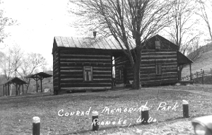 |
It is interesting to pause for a moment and mention this old homestead and the events to follow. It was erected about 1845 by William Rohrbough, of hewn logs with an annex, as was the custom in that day, and it has seen many years service. Just below is still to be seen the "old well and sweep" at the side of which has stood such illustrious men as William McKinley, Rutherford B. Hayes, both of whom became Presidents, Brigadier Generals Goff, Rosecrans, E. B. Scammon, J. A. J. Lightburn, and many lesser lights. Whitelaw Reid likewise paused long enough to pick up a few reflections for the writings of "Agate" in the Cincinnati Commercial Tribune. He was later Ambassador to England.
In September, 1861, the local station of the Federal military express, then being conducted under the supervision of Captain Charles Lieb, A. F. Newman and Michael Egan, was moved from Crowls, just below, to this home place. Feed for the express messenger's horse cost 15›, and the messenger paid 25› for his meals. Two or more horses, and messengers were located here for some months, and Uncle Sam agreed to pay the munificent sum of $8.00 per month for regular service. One bill amounting to $32.60 has never been paid, and George Conrad's revenue therefrom consisted of a notation by Chas. Lieb that he had given him 11 bushels of oats as a credit for $2.75. Such was the universal history of the famous "courier express system."
Turning to the operation of the post office, the mail during the Civil War period was carried under contract by Esaias Fetty, who was one of the commissioners to divide the county into districts, in 1863, and died near Camden December 27, 1881. The receipts from July 29, 1862 to December 31, 1864, amounted to $9.42. According to a statement covering the period from 1862 until 1872, the receipts for the first quarter amounted to 13 cents. The first quarter in 1864 was $1.26. Indeed one smiles at the smallness of it all, but as soon as the was closed the first quarter jumped to $6.33. Passing down the 1872 the second quarter showed $8.02 so it will be seen that the office was gaining.
An oddity is observed in the fact that, though West Virginia was admitted to the Union June 20, 1863, the government kept on calling the office Bush's Mills, Virginia, until late in the fall of that year.
But the post office department in contrast to the army was very thorough in that day, for on October 3, 1863, the third assistant postmaster general wrote "a credit of $3.00 for a deficiency of 100-3 cent stamps will be reported to the auditor for entry in your general account." And some years later wrote the pleasing message that "the postmaster general has ordered that your salary be fixed at $47.00 from July 1, 1873, to June 30, 1874, instead of $17.00 as heretofore." Verily the job must have sought the man and not the man the job.
During the war on many an occasion it was necessary to hastily secure such few effects as in the office and take to the hills from danger from guerillas, as well as southern troops.
The duty of postmaster at this time also included the task of collecting the tolls from the traveling public, a custom now only recalled in sections of old Virginia, but then the means of support of the public highway. In addition he also acted as general agent for newspapers and magazines. Instead of coming postage paid the method was reversed, and if they weighed less than 4 ounces 5› a quarter was collected from the subscriber. In 1871 during the first quarter 28 letters, seven registered letters and 13 free papers were received in addition to others.
The people kept well informed for that day. Thirteen "West Democrats" were in evidence, as well as copies of the "Wheeling Register," "Toledo Blade", "Phrenological Journal", "The Ladies Cabinet" and "Waverly Magazine". Journals on bees seemed to be popular as well as Methodist publications. New York papers came to a few, and one from Hinton to some homesick citizen who had removed from Summers County.
 |
Of the fifty some subscribers some only received one a month, and others, as in the case of George Cook, received six. The Wheeling Register, in later years, commenting upon this office says: "Here was a small and inaccessible community in the mountains of West Virginia that received more current literature every month than was circulated in some of the most densely populated provinces of Europe in a year. No wonder the Yankee pioneers forged ahead. They never allowed themselves to get behind in the world's affairs no matter how far removed they might find themselves from the world's activities." |
With the location of the Conrad family came the first church organization of a permanent character in the community. On July 17, 1858, under the direction of Elders Carr and J. B. Bailey, the "West Fork Church" was established under the jurisdiction of the Broad Run Baptist Church Association. J. P. Conrad was elected deacon and W. R. Dennison clerk, who was succeeded by I. N. Conrad. The signers of the "covenent" were Mary, Joseph P., George W., Isaac N., Nancy A., and Mary A. Conrad, Jennie Ambrose, W. R. Dennison, Joseph Clark, Mary Garrett, and Mary A. Clark.
| A small church building was constructed, located on the river "bench" below the site of the Seventh Day Church. This served not only the church body but for local meetings and as a school house, and was long known as the "Union School House." Services were held - with intermission during the Civil War - until the latter part of 1880, at which time support had become so small, due to the rise of the Methodist Protestant faith, that the organization was dissolved. The records show, among the names of ministers, that of Brigadier General J. A. J. Lightburn, who had | 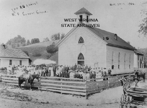 |
Charles A. Hornor was born in Clarksburg, June 7, 1850, and died at Clarksburg November 12, 1921. On March 11, 1873, he married Mary V. Rhodes, daughter of Erasmus and Elizabeth Hevener Rhodes, and served as sheriff of Lewis County 1885-1889. On June 18, 1874, he was named postmaster to succeed George Conrad. As a result of the change, and the beginning of what was hoped to be of a new town, William E. Arnold came forward with the suggestion that the new post office be called Roanoke. It was so ordered by the department and the time-honored name of Bush's Mills ceased to exist. The present name has no connection whatever with any local family or history, and later caused so much confusion with the rise of the city of like name in old Virginia, that the railroad company made it still worse by changing to Roanville as a freight station.
Doctors T. G. Edmiston and M. E. Whelan located in 1878. The last named is still practicing. Dr. M. R. Casey followed later who was succeeded by Dr. C. N. Reger. Dr. John O'Brien located in 1823.
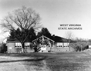
In 1883 William K. White opened the first hotel. He was a son of Thomas White, the first Irish settler on the Sand Fork of the Little Kanawha. This institution later passed to Silas Butcher and from him to John Gillooly. H. L. Powers opened a store in 1883. I. C. Waldo and Owen Mullooly established a store in 1884. Lot No. 1 was sold at court October 23, 1886. By 1885 there was enough local support to justify a church building, and the M. P. Church was dedicated July 14, 1886, occupying a lot adjoining the school building erected in 1882. The Sand Fork was bridged in 1884 by John Oden at a cost of $294.50.
During 1888 men appeared in the community securing rights of way for a railroad, which presaged the coming of the West Virginia and Pittsburgh railway. On August 21, 1889, the Weston and Elk River Railroad Company awarded a contract for the construction of the first 25 miles of track. By the summer of 1890 the small boy found entertainment and many of his elders employment in connection with the construction work. During this time an epidemic of typhoid fever broke out among the laborers and at one time 123 cases existed between Roanoke and Confluence with only two physicians available.
Old "Number Ten" with small semblance to the present day locomotive, loaded down with a big funnel smokestack, and train of work cars "strained and screeched" around the multitude of curves along the river and was the first to enter the village. Work was pushed rapidly on this line under the guidance of J. N. Camden and C. N. Lord and by May, 1891, the "Old Gauley" passed through Roanoke bearing officials on an inspection trip to Sutton, then the end of the line.
Roanoke and Arnold then took on new life. Travel over the roads declined and the Arnold line of hotels fell into disuse. In the spring of 1891 Thomas Feeney, who had been connected with the Hornor establishment, opened a new store in a more pretentious building. The famous "Roanoke Marine Band" was organized comprising in its membership several who have since made their mark in the world. In 1894 D. B. Cook, who had gained considerable prominence in local newspaper circles under the name of "Sam Badger" established the "Willing Worker". Publication was suspended the following year when the owner became affiliated with the "Weston World" and is at present one of the owners of the Weston Independent, its successor. In the same year Enoch A. Gaston succeeded Charles A. Horner, and Silas Butcher became postmaster serving until 1896. The Gaston store was later burned, and was owned at the time of the fire by W. E. Mullooly. O. J. Whitsell and R. W. Duncan opened a store about 1899 in the new I. O. O. F. building.
A survey of the town in 1896 shows four general stores, blacksmith shop, harness shop, millinery store, hotel, photograph studio, mill, church, school and two physicians. The station was then rated as one of the largest shippers of poultry in West Virginia. Flora B. Conrad was postmistress serving until her untimely death on April 7, 1900 when she was succeeded by Rose D. Conrad.
John H. Conrad, mentioned elsewhere, became postmaster December 18, 1901, and was succeeded by Mary A. Conrad, on December 16, 1908. From January 24, 1915 until March 24, 1921 George R. Snyder occupied this office when Miss Conrad the present incumbent again assumed the office. Several rural routes are served and a large volume of business is handled.
Tradition relates that the first permanent settler on the site of Arnold Station was Lewis L. Duvall, who after a short period of residence at this point removed to Freeman's Creek where the family had a large holdings acquired by John P. Duvall, the founder of the family in the Monongahela Valley.
George T. Duvall and a sister Mary Ann Duvall, took up their residence at this point very early in the nineteenth century. The last named was born in Hardy County in 1793 and died at the "Indian Farm" July 25, 1866. Much of the Duvall patents passed into their hands including the 1400 acres grant in 1786 that embraced the "Indian House" and the "Indian Carrying Place".
George T. Duvall was born in Hardy County, in 1784, and died at the Indian Farm January 29, 1876. On March 11, 1817, he was appointed a constable for this community, appeared before the County Court and gave bond with Henry Camden and James Kieth as sureties. Later he served as a justice or "squire" for a number of years. He was a man of some education for that early day, and possessed a great deal of enterprise and had much influence in this region. About 1812 he married Polly Godfrey who was born in Hardy County in 1792 and died June 7, 1866. To this union several children were born among whom was a son, George Washington, who served through the Civil War and later became U. S. District Attorney for Kentucky.
Following Duvall came John Taft or Teft, who located nearby, and acquired a tract of land of some size. The location or accurate information as to this family and its occupancy is somewhat obscure, but they appear to have ben early settlers in Wood. County. In later years the heirs transferred some 518 acres to George J. Arnold. Jonathan M. Bennett interposed some objections to the title of some 160 acres of this tract which had been transferred to George T. Duvall, by J. Talbott, Clark of County Court, August 29, 1837. An agreement of adjustment was filed October 11, 1851 covering lands on Oil Creek and Indian Carrying Run, adjoining the 1400 acre patent to J. P. Duvall.
Manuel Kieth settled near by on a tract of 55 acres purchased from Lewis and Sarah Duvall, December 30, 1823, and his widow Margaret Kieth on June 11, 1872, transferred this tract to George J. Arnold.
On August 7, 1857, George W. Duvall transferred to George Jackson Arnold the land lying on the head of Oil Creek and Indian Carrying Run, adjoining lands of George T. and Lewis L. Duvall, and others. Here Mr. Arnold in later years erected a splendid county home, which was destroyed by fire about 1899. He was born in Fauquier County, Virginia, in 1816 and died in 1899. He served in the Virginia Assembly and wrote the bill creating the State of West Virginia, and later served in the Legislature. A son, Jackson Arnold commanded Company F, Second West Virginia Infantry in the Spanish American War. He also served as Lieutenant-Colonel in the war with Germany and is at present head of the Department of Public Safety of West Virginia.
With the completion of the Weston and Gauley Pike and the close of the Civil War, George J. Arnold established several hotels along this noted roadway. The first was the Rushville house on Rush Run, long operated by I. C. Waldo, Jr., The second was the noted Valley House, located about a mile below Arnold Station. The building it occupied was constructed prior to the Civil War, of large hewn logs, and in later years was covered with "weather boards". The old structure with its quaint outside stairway is still standing by the roadside, much the worse for the wear and tear of three quarters of a century. It was and is still often referred to as the "Waldo Place." In 1890 the Indian Farm Hotel was erected near the Arnold home. It was burned in September 1923.
The first oil and gas explorations were conducted in the immediate vicinity in 1912 resulting in light gas wells. On the Canoe Run side of the divide a test brought similar results. Work was then abandoned until 1923 since which time several good gas wells located on Sand Fork and around the mouth of White Oak Lick have been brought in.