

Early Land Grants and Settlers Along Patterson Creek
By Charles Morrison
Volume 40, Number 2 (Winter 1979), pp. 164-99
By the meanders of the river, Patterson Creek joins the Potomac about thirteen miles below the mouth of Wills Creek, which is at the site of old Fort Cumberland. The origin of the name is uncertain. Early maps of the upper Potomac show the name as Pattisons or Patersons. These maps were based on a survey of the Potomac made in 1736 by Benjamin Winslow, William Mayo, and others, on behalf of the Colony of Virginia and Thomas 6th Lord Fairfax. They are the first accurate maps of the region.
Hamill Kenny, in West Virginia Place Names, associates the name of the stream with that of a person or family.1 Whatever the origin, it must have been applied to the Creek before any permanent settlers arrived and possibly even before 1736. The name Patterson does not appear in any official record for Hampshire County, except as a place name, until near the end of the century, or about 1790. On the other hand, the family name Batson occurs in the census for both 1782 and 1784. Bateson, too, is a family name that is associated with the Potomac's North Branch in western Maryland.
Although the official name of the stream is Patterson Creek, it is usually referred to locally as Pattersons Creek. In this article the form has been used that seems to best suit the context; and as is correct, up and down, and above and below refer to the direction of stream flow and not to conventional map directions. Furthermore, in the interest of readability, the word Creek when spelled with a capital C refers to Patterson Creek; likewise, Mountain refers to Patterson Creek Mountain, and Valley to Patterson Creek Valley.
Place names have been used generally as they existed at the time of the event or circumstance described. If the name has since been changed, the newer name follows in parenthesis if needed for identification.
Names of people, both surnames and personal, have been spelled as they appeared in the references from which they were drawn. Early writers were not always consistent; therefore, variations will occur in the spelling of names throughout the text. As an example, Abram Johnstone may appear later as Abraham Johnson, etc. Hopefully, the context will make it clear that the reference is to the same person.
Patterson Creek drains an area of approximately 283 square miles. From its headwaters just above Lahmansville in Grant County, it flows generally north 33° degrees east, in a meandering course some thirty-seven miles to its junction with the Potomac. This gives it a drainage area averaging about seven and one-half miles in breadth.
Numerous tributaries join Patterson Creek in its passage from the vicinity of Lahmansville to the Potomac. These tributaries emanate from countless coves and hollows amongst the mountains that line the Valley. Cascading down the hillsides, they provide many scenes of quiet charm and spiritual beauty, and it is not difficult to imagine why this narrow valley beckoned to the pioneers almost as soon as the tide of settlement touched the South Branch Valley to the east.
Once the Blue Ridge barrier was breached, where the Potomac and the Susquehanna find their ways to the sea, the Indian road to the south became a thoroughfare into the unspoiled Virginia back country. By way of the McCullough path the more venturesome reached the fertile valley of the South Branch. From there, Patterson Creek was readily accessible by way of Lunice Creek or the passes between the ridges of Patterson Creek Mountain. New Creek, still further west, could be reached through Greenland Gap and the headwaters of Patterson Creek's North Fork. This sweeping tide of settlement all took place within three decades - 1720 to 1750 - spreading westward as it swept south.
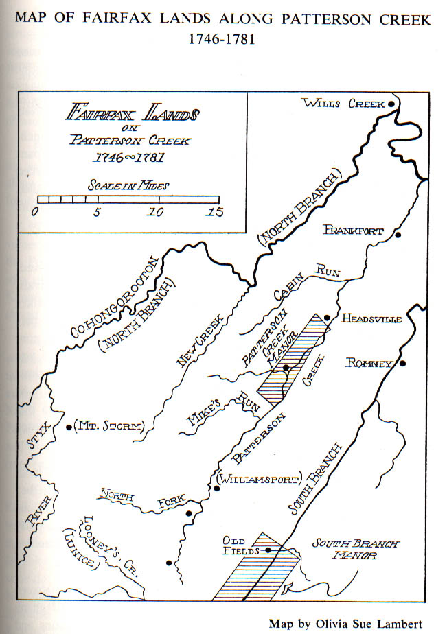
In 1745 these valleys, north of a line surveyed between the sources of the Potomac and Rappahannock rivers, became part of a vast proprietary grant, known as the Northern Neck.2 This included all of the Patterson Creek Valley. The grant was an old one, having been made by Charles II in 1649, while in exile, to several his friends and supporters, including two members of the prominent Culpeper family. Over the years the Culpepers acquired the entire interest, and then through marriage it passed to the equally prominent and more enduring Fairfax family.
In 1719 this royal grant was inherited by Thomas 6th Lord Fairfax. The exact boundaries of the Proprietary had never been properly determined, partly because of disagreement over the language of the grant and partly because the geography of Virginia west of the Blue Ridge was almost unknown when the grant was made.
Thomas Fairfax was interested not only in establishing his inheritance, but also in getting the most out of the meaning of its terms with reference to the heads of the rivers involved - the Potomac and Rappahannock. Despite understandable opposition by the colonial government, Fairfax was politically successful in obtaining the most liberal interpretation of his patent and in the definition of the branches and sources of the two rivers.
In 1746 the back line as it was then called, was surveyed from the source of the Potomac's North Branch to that of the Rappahannock's southern branch, known as the Conway River. Quickly the Proprietor moved to have some of the best land within his newly acquired boundaries laid off as manors.
South Branch Manor, consisting of 54,596 acres, was surveyed by James Genn, the recorded date being March 31, 1747.3 It included the most valuable land along the South Branch from Royal Glen Gorge to The Trough as well as the lower reaches of Mill Creek and Lunice Creek. From the headwaters of the latter, Genn's surveyors could readily cross the low divide to Pattersons Creek.
There, about a half-mile below the mouth of Mikes Run as it appears today, on the east side of the Creek at the foot of the Mountain, they commenced the survey of Patterson Creek Manor. This was about where the gently rolling land upstream begins to level off, with the Creek meandering across the floor of the Valley, between the Mountain on the east and higher ground to the west. The survey of Patterson Creek Manor is dated April 8, 1747,4 just eight days after that of the South Branch Manor.
Generally, the manor line followed the edge of Patterson Creek, or the foot of the Mountain to the vicinity of the present community of Headsville. There it turned northwesterly for about eight thousand feet; then southwestward for approximately eight miles, partly through the hilly country a mile or two west of the Creek; and finally southeasterly to the point of beginning.
The survey, as recorded, is worded and punctuated as follows:5 BEGINNING on the East side of the sd. Creek at a large white Oak Mark'd /F/ at the Foot of A Mountain & thence No. 60.Et. Three hundred & forty eight poles to another large white Oak/F/1 & thence No. 31.Et. One Thousand three hundred and Fifteen poles to a white Oak /F/ & thence No. 30.Et. Four Hundred and Eighty four poles to another white Oak /F/ & thence No. 35.Et. Four hundred and eighty poles to a red Oak /F/ & thence No. 35.Wt. Four hundred and eighty poles to a forked Maple /F/ & thence So. 43.30" Wt. Four thousand five hundred & forty poles to a white Oak /F/ & thence So. 35.Et. Five hundred & forty eight poles to the BEGINNING Containing TEN THOUSAND ACRES . . . .[6]
Mistakes become evident when the courses and distances are plotted on paper. In surveying language, Genn's survey does not close; in fact, the failure to close represents a mistake of about six miles, one that was not likely to escape the attention of a surveyor of Genn's reputation. In comparing Genn's survey with one made later by Joseph Neville, it is discovered that the fourth course of Genn's survey, No. 35. Et. Four hundred and eighty poles, should have been recorded No. 53.Et. With this correction Genn's survey becomes more manageable, but it then becomes apparent that the sixth, or next to the last, course should have been recorded Two Thousand seven hundred & forty poles, a mistake of more than five and one-half miles.
These corrections and some minor adjustments in Neville's make the two surveys reconcilable. In addition, once the manor is located along the Creek, some of the topographical features mentioned by Neville can be identified on modern maps of the U.S. Geological Survey. One observation should be noted, however, in some places, within its flood plain, the Creek channel has shifted since Neville's survey was made.
Neither Genn's nor Neville's survey gives any clue as to the location of the manor along the Creek. Stream names, except that of Patterson Creek, have changed over the years; and there were no established towns or specific reference points with which to relate their surveys.
There were settlers along Pattersons Creek when Genn first visited it in 1747. Next year, when he returned to continue his surveys for Lord Fairfax, he brought with him, in addition to his surveyors, two youthful observers.7 One was George William Fairfax, son of the Proprietor's cousin; the other one was George Washington, a friend of the younger Fairfax. The party was on its way to the South Branch of the Potomac by way of Cresap's trading post in Maryland.
In his Journal of My Journey Over the Mountain,8 young George Washington mentioned Abram Johnstone as living "15 Miles from the Mouth" of the Creek. The party camped at Johnstone's overnight and the next day travelled up the Creek to the settlement of "Solomon Hedges Esqr one of his Majestys Justices of the Peace for the County of Frederick where we camped . . . .9" Hedges lived at the site of the present Fort Hill Farm, about three miles south of Burlington.
On his journey up the Creek with Genn's surveyors, Washington must have passed the sites of the future forts "at Ashby's" and "at Cocke's." A few days earlier, on March 23, at Cresap's trading post, he had been amused by the war "daunce" of a visiting party of friendly Indians. Within the next decade Washington would learn more about Indian behavior than he cared to, and the thought of their war dances would be far from amusing.
Although the two young visitors soon returned to the more civilized atmosphere of tidewater, Genn and his surveyors continued their work along the South Fork, the South Branch, and Pattersons Creek. As a result numerous grants were recorded for land along Pattersons Creek below (north of) the manor.
These were grants in fee, or forever; that is, they could be deeded, willed, inherited, assigned, etc. in accordance with English law, subject only to the payment of certain recording fees and the initial "composition money" of ten shillings per one hundred acres,10 plus the annual quitrent of two shillings per hundred acres, payable to the Proprietors of the Northern Neck "Yearly and every Year on the Feast Day of St. Michael the Archangel . . . ."
Sixteen lots were granted in 1748-49, as follows. These are recorded in Northern Neck Grant Book G, now in the safekeeping of the Virginia State Library at Richmond.
| John Adam Long | 293 acres | Lot No. 2 | Oct. 2, 1748 |
| Capt. John Greenfield | 200 acres | Lot X | Oct. 7, 1748 |
| Nicholas Reasner | 277 acres | Lot No. 3 | Oct. 23, 1748 |
| George Parker | 399 acres | Lot No. 1 | Oct. 25, 1748 |
| John Ratan | 354 acres | Lot No. 4 | Oct. 25, 1748 |
| Abram Johnson | 293 acres | Lot No. 5 | Oct. 26, 1748 |
| Power Hasel | 328 acres | Lot No. 8 | June 3, 1749 |
| Joseph Hamlin | 289 acres | Lot No. 11 | June 7, 1749 |
| John Parker | 312 acres | Lot No. 12 | June 8, 1749 |
| Mathew Rogers | 379 acres | Lot No. 13 | June 10, 1749 |
| Jacob Good | 394 acres | Lot No. 13 | June 11, 1749 |
| Philip Martin | 283 acres | Lot No. 22 | June 11, 1749 |
| Joseph Robinson | 332 acres | Lot No. 21 | June 11, 1749 |
| Joseph Walter | 238 acres | Lot No. 15 | June 11, 1749 |
| Nicolas Crist | 167 acres | Lot No. 10 | June 22, 1749 |
| David Thompson | 312 acres | Lot No. 6 | June 22, 1749 |
Notes:
1. Lot No. 1 was adjacent to the northeastern boundary of the Patterson Creek Manor, at the present village of Headsville. In 1755 it was designated by Washington as the site of a defensive fort to be garrisoned by Captain William Cocke's company of the Virginia Regiment. However, the fort may have been built about one and one-quarter miles to the south on a hill on the east side of the Creek. This would have placed it within Lot No. 12 of the Patterson Creek Manor.
2. Lot No. 2 conveyed by Christian Long to John Reno on March 25, 1761.
3. In 1755 Washington considered Reasner's plantation, which was on Lot. No. 3, as a possible site for the defensive fort he later ordered built at Parker's, Lot. No. 1. In 1795 Jacob Reasner willed land on Pattersons Creek and Cabin Run Hill to his children; and to John Murphy, land adjacent to William Rees' shop. See following entry.
4. Lot No, 5, granted to Abram Johnson, was the scene of Washington's first overnight camp on Pattersons Creek when he accompanied Genn's surveying party in 1748. Johnson then, or soon thereafter, had a mill nearby. In 1790 he sold 219 acres, and probably the mill to William Reese. This may be the origin of the name of the Reeses Mill community. In 1795 George Reese sold 352 acres on Johnsons Run to John Daton.
5. David Thompson conveyed Lot No. 6, 312 acres, to Jacob Reasoner in 1790. In 1795 this land was conveyed by mill to Reasoner's ten children.
5. [sic] The reason for the designation. Lot X, is uncertain. See Map Note 4. It included the mouth of Cabin Run, and today is crossed by W.Va. Route 46 at the intersection with W.Va. Adj. Route 11 to Headsville. In 1767 Captain Greenfield sold his 200 acres to Alexander Gibbony; a year later Giboney sold it to Joseph Neavill, Jr. In 1775 Neville may have sold the same 200 acres to Okey Johnson. The same day Johnson sold it to Simon Purgatt (or Job Bacorn).
6. Lot No. 9 was surveyed but not granted in 1748-49. However, on September 18. 1771, it was sold by Edward Scott to John Carpenter, and by him to Thomas Holoback on March 11, 1777.
7. Lot No. 10 was sold by Jacob Crist to Okey Johnson on November 5, 1774.
8, Joseph Hamlin may have sold 50 acres of Lot No. 11 to Henry Bagley in 1761.
9. John Parker leased and conveyed his holdings on Pattersons Creek by 1775 to William Johnson and Peter Puttman.
10. Lot No. 13 was apparently subdivided; in 1767 William Rogers conveyed 264 acres to James Rogers, and in 1772 Jonathan Rogers sold the remaining 115 acres to Peter Jones.
11. Jacob Good's holdings were distributed by his will, probated in 1780, to his wife, Susannah, and his sons, Peter, Abraham, and Isaac.
13. Lot No. 16, 300 acres, was surveyed by James Genn in 1748 for Charles Keller, or Sellers, but later forfeited, presumably for non-payment of the required fees and composition money, or the annual quitrent. Actually, Keller was killed, probably on his own land surrounding Fort Ashby, during the French and Indian War. The reasons for the forfeiture may have been taken into account by Lord Fairfax. The same lot was granted to John Keller of Lancaster County, Pennsylvania, son and heir at law of Charles Keller, by deed from the Proprietor's office on June 1, 1779. There is some confusion between the names Keller and Sellers. Fort Ashby was built by Washignton's [sic] instructions "at the Plantation of Charles Sellars. . . ."11 John Keller became one of the developers of the town of Frankfort, now Fort Ashby, but his name as Keller is not included in the census for Hampshire County for either 1782 or 1784. However, John Sellers is listed both years. Infra.
14. Joseph Robinson sold his 332 acres, Lot No. 21, to William Campbell in 1773. Thirteen years later Campbell sold it to Balson Shelhorn, who apparently disposed of it to Abraham and Peter Eversal in 1794.
15. Philip Martin, a nephew of Lord Fairfax, leased Lot No. 22 at the mouth of Pattersons Creek to John Hartley on August 8, 1769, for the lease rent of Three Pounds per year. Martin never occupied the land. He was a captain in the British army, stationed in Newfoundland, at the time of the lease. Later he acquired the Patterson Creek Manor by deed from his uncle, but he may never have visited any part of his Patterson Creek estate. His original grant, Lot No, 22, may have been the site of a small fort established for the protection of stores during the French and Indian War. Infra.
16. Lots No. 7 and 17 to 20, were surveyed in 1748 or 1749, but were not granted during those years. They may have been occupied, however, and the grants issued later. In two cases blank deeds were prepared; that is, with no name inscribed and the word eight or nine omitted after the date "One thousand Seven hundred and forty . . ." This was apparently an omission which has led to the conclusion that at least one Patterson Creek grant was made as early as 1740. No grants could have been made properly prior to 1748. Since the deeds in question mention the twenty-second or twenty-third year of the reign of "our sovereign Lord George the Second by the Grace of God . . .," it is evident that they were prepared to be issued in 1748 or 1749.
It is too often believed that early land grants were likely to remain in the same family for generations. This was sometimes true, but often it was not. Life in that pioneer society could be transitory. Intestate inheritance, under the English law of primogeniture, resulted in some land grants being inherited by an heir of the same surname, and then disposed of. Warrants of survey, too, were transferable, although they were not recorded. These were issued on the basis of a claim or occupancy, and within two years entitled the holder to a grant on payment of the necessary fees and composition money.
As an indication of the frontiersman's attitude towards the formalities with regard to land records, it may be pointed out that Sims Index of Land Grants in West Virginia12 does not include any of the early Fairfax grants that have been listed. Prior to the formation of Hampshire County in 1754, Patterson Creek grants would have been recorded, if at all, in Frederick County, and before that in Augusta County. Sims includes these two counties in his Index, but the names listed above do not appear. Like most holders of Fairfax grants, the grantees were content to have their deeds recorded in the Northern Neck land office and nowhere else; or perhaps they were unaware of any distinction. Even more likely they were not concerned as long as they were not disturbed.
Moravian missionaries, who preceded Genn's surveyors by nearly a year, mentioned many people, German and English, who lived on Batesons Creek.13 Amongst them, in addition to Solomon Hedge, were Abraham and William Degart, Oliver Creamer,14 and a man by the name of Kasselman. They described the people as being religious, but uncertain about the Moravian beliefs. When one of the itinerants refused to marry a man who was described as the son of an Englishman Solomon Hedges threatened to put him in the nearest prison. That seemed not to happen and Hedges signed their passports and directed them over the mountain to theSouth Branch, probably by the same road taken by Genn and his surveyors later.
The Moravain diaries also provide us with an interesting glimpse of life as it existed along the Creek in 1747.15 Piecing together the facets of primitive life on the Virginia frontier, it is easy to understand why many of the early settlers had little time or concern for the formalities of land tenure. Many of them lived on the land they found, without benefit of any official record. And for a time it seemed that Lord Fairfax was a rather lax or tolerant landlord; either that, or he was preoccupied with concerns more immediately around him.
In order to maintain a degree of perspective it will be necessary to depart from a strictly chronological order of events and more to the year 1793. This was thirty years after the French and Indian War and twelve after the death of Lord Fairfax and the surrender at Yorktown.
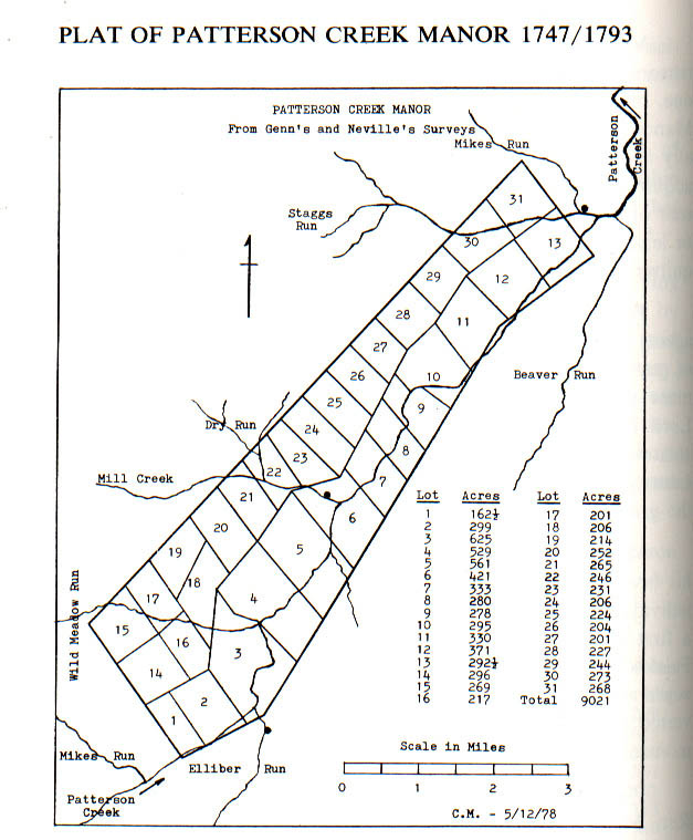
On September 7, 1793, a survey for the Patterson Creek Manor was recorded at a Superior Court held at Hardy County Courthouse for the counties of Hardy, Hampshire and Pendleton. The manor was subdivided into thirty-one lots. Its area, according to the survey, totalled 9021 acres.
At that time the surveyors, Joseph Neville and John Moffett, appeared and testified that the survey was made on November 20, 1772, "pursuant to the Right Hnble Thomas Lord Fairfax's order of April 27, 1761." It seems rather unlikely that more than ten years had elapsed between the date of the order and its execution. Since the survey was not recorded for more than thirty years after the supposed date of the order, memory may have failed the surveyors or an error was entered into the court record as to the year of the survey.
For this and other reasons it seems likely that Neville's survey was made in 1762. Lot by lot, it is recorded in considerable detail, using then existent natural landmarks.16 The corners are described in terms of two black Oaks and a white Oak, a red Oak by a Declivious bank of the Creek, three white Oaks and a Hicory by a Branch, etc. In an accompanying plat the streams are shown but the names do not coincide with those in use today.
There are some inconsistencies here and there between the surveys of adjacent lots, but with some experience in plotting colonial land surveys Neville's notes can be transcribed with some confidence into a plat showing the relationship of the thirty-one lots. There is no indication, however, as to the position of the manor lines with respect to any fixed position along the Creek.
Locating the Manor on a map became a bit like fitting together the pieces of a jigsaw puzzle. A search at the Virginia State Library revealed the surveys of the twenty-three proprietary lots that were laid out by James Genn along the Creek between the Manor and the Potomac. Several of these lots have been listed in the previous tabulation.
Lot No. 1 is described as follows: "BEGINNING at a white Oak in the Manor Line on the east side of the said Creek and extending thence No. 55 Et Two hundred and eighty Poles to a white Oak red Oak and Hickory on the Top of a Hill thence No 35 Wt. crossing the Creek Two hundred twenty eight Poles to a blac Walnut, thence So 55 W Two hundred eighty Poles to the Manor Line Finally therewith So. 35 Et. Two hundred twenty eight Poles to the Beginning ... ."17
From Lot No. 1 to the Potomac, the lots each have one common boundary with another, so that a continuous plat can be drawn and fitted to a present-day map or maps of the area, with Lot No. 22 bordering on the river. Unnamed but permanent topographical features mentioned in the surveys may be matched against the same on the map to adjust for errors in distance introduced by the simple surveying methods of colonial days. This plat, when fitted to the positions of the Potomac River, Patterson Creek, and Cabin Run, the only three streams identified in the surveys, establishes within reasonable error, the position of Lot No. 1, and of the Manor line.
This boundary came so close to the present-day community of Headsville, in Mineral County, that it seemed desirable to verify if possible whether it was to the north or south of the village. Mr. J. W. Carskadon, who lives there, was of the opinion that the Manor line crossed the Creek just above, that is south of, Headsville.
Genn's and Neville's surveys were reconciled and then placed on the map, contiguous to Lot No. 1, to locate the remaining boundaries of Patterson Creek Manor. Again, by adjusting the plat of the Manor to those identifiable features of the terrain which time cannot alter, errors in distance were corrected. This placed the southwest boundary of the Manor so that it crossed the Creek about six thousand feet above the mouth of Elliber Run, which joins the Creek near Russeldale, and crossed the existing Patterson Creek Road about three and three quarter miles south of Burlington.
Inquiry at Fort Hill Farm,18 which includes Lot No. 3 of Neville's survey, confirmed the accuracy of that position to within about three hundred feet. In fact, a map of the farm indicated that some of its boundaries coincided with Neville's survey of Lot No. 3.
Of interest to genealogists may be the names of those living within Pattersons Creek Manor at the time of its subdivision by Neville, presumably in 1762. Until that time they had probably paid no rent. Manor land was usually the best land within the Proprietary, and it was almost always reserved by the Proprietor for his own use or to be leased to those who for one reason or another had no permanent interest in the land. The least rent was usually ten shillings per one hundred acres - five times the fee rent for an outright grant in non-manor land.
The following occupants or claimants of land in the Patterson Creek Manor appear in the notes of Neville's survey.
| Lot No. | Occupied or Claimed by | Acres |
| 1 | Thomas Douthitt (or Southitt) | 162 1/2 |
| 2 | George Corn | 299 |
| 3 | Solomon Hedges | 625 |
| 4 | Benjamin Rutherford | 529 |
| 5 | Reserved for Lord Fairfax | 561 |
| 6 | Edward Corn and Philip Langly | 421 |
| 7 | Timothy Corn | 333 |
| 8 | Windle Miller | 280 |
| 9 | John Ramsey | 278 |
| 10 | Joseph Barker | 295 |
| 11 | Robert Bell | 330 |
| 12 | Charles Savours and Samuel McMurray | 371 |
| 13 | Nicholas Seavours | 292 1/2 |
| 14 | John Moffitt | 296 |
| 15 | 269 | |
| 16 | 217 | |
| 17 | John Hared | 201 |
| 18-31 | Not claimed or applied for at the time of the survey; these were the less desirable lots in the rolling country west of the flood plain. (For the location of these lots within the Manor see Plat which accompanies this article) |
Various conjectures have been expressed as to Lord Fairfax's reasons for establishing his manors. Additional profit may have been one, but this does not appear to have been the overriding motives.19 Manors were prevalent in Virginia before the Revolution, but generally they were nothing more than extensive tracts of preferred land acquired by an individual under a colonial patent at an annual fee rent of two shillings per hundred acres. Within these manors, grants or leaseholds could be made at considerable profit - double or triple quitrent for a grant, and even more for a lease.
Prior to his arrival in Virginia in 1735, some of Lord Fairfax's agents had used this right, reserving for themselves immense tracts of good land from which they hoped to profit as the tide of settlement pushed westward. For reasons that are not altogether clear, Lord Fairfax saw fit to follow the example of his agents. Perhaps this was nothing more than a defensive move on the part of the canny Baron in an effort to protect the best land that remained from the grasping hands of those around him.
Most of the manors were deeded or willed by Lord Fairfax to his favorite nephews, Thomas Bryan, Philip, and Denny Martin, as individuals. One, Great Falls Manor, was granted to Bryan Fairfax, a first cousin, once removed, who in 1800 became the 8th Lord Fairfax. Two manors, near the mouth of the Shenandoah, were surveyed in 1736, but were never granted.20 For that reason they reverted to the Proprietary, and as such became vested in the Commonwealth of Virginia after the Revolutionary War.
Those of most interest here are the Manor of Leeds, Gooney Run Manor, South Branch Manor, and Patterson Creek Manor. These became the subject of intense and protracted litigation in the years following the Revolution, touching in no small way the career of John Marshall, even after his appointment as Chief Justice of the United States.
On August 21, 1767, Lord Fairfax granted outright to Philip Martin his Patterson Creek Manor21 as recorded in Genn's survey of April 8, 1747. On the same date he conveyed the remaining manors to Thomas Bryan Martin, Philip's brother. With this, the Proprietor disposed of, at least for the time being, all of his manors, Greenway Court having been granted earlier to Thomas Bryan Martin as an outright conveyance. It was at Greenway Court that Lord Fairfax made his home with his nephew. This was also the Proprietary Land Office.
 |
Author's Notes
1. Plat drawn from Genn's survey, 1747, and Neville's plat, recorded September 7, 1793. 2. Stream names are as shown on recent maps of the U.S. Geological Survey. 3. On Neville's plat Wild Meadow Run is Hamptons Run: Mill Creek is Ed. Corns Run and Staggs Run is Parkers Mill Run. Other tributaries appear on Neville's plat, many unnamed. However, from the east a Meadow Run joins the Creek within Lot No. 7; from the west, Hoglands Run flows through Lots No. 24, 25, and 7 to join the Creek on the boundary between Lots No. 7 and 8. Across the flood plain the courses of some of these tributaries have changed since Neville's plat was made. |
4. Communities are about as shown on maps of the U.S. Geological Survey. From north to south: Headsville, near the mouth of Staggs Run, northeast of Lot No. 13; Burlington, near the mouth of Mill Creek, within Log No. 6; Russeldale, near the mouth of Elliber Run, southeast of Lot No. 3.
With the exception of Greenway Court, the manors granted to Thomas Bryan Martin on August 21, 1767, were later reconveyed to the Proprietor by means of a legal device quite common at the time, known as lease and release.22 By this means Lord Fairfax established the three manors as a part of his personal estate, within but legally separable from the Proprietary. As his own tenant he could and did devise by will the three manors to another nephew, Denny Martin, brother of Thomas Bryan and Philip Martin. The three were sons of Frances Fairfax Martin, favored sister of the Proprietor.
What was it in 1767 that motivated the Lord Proprietor of the Northern Neck to move toward the final disposition of his manors? By that time the French had been successfully driven from North America; there was no threat to British sovereignty from that quarter There had been some dissatisfaction with British performance during the French and Indian War, but the charge could not be made that Lord Fairfax had done less than his part during the struggle.
Were the unravelling bonds of British sovereignty in the colonies becoming apparent to the wary Baron of Cameron? Did he sense the seeds of revolution germinating around him, and seek to protect the manors under his tenant's rights even though, as he must have known, his proprietary rights would be preempted? Or perhaps his preoccupation with the protracted suit of Jost Hite and others over lands in the Shenandoah Valley precipitated his move to protect the best of what remained of his royal grant.
So much for the reasons for the manors and their disposition. What of the land itself and its subsequent history? What of the people who found it, and the people who were there first? The valley Patterson Creek is not unlike those to the east and the New Creek Valley to the west; nor are these unlike their counterparts to the south as they unite to form the James. In fact, the two river system are patterned very much alike, as if this were the kind of land of which there must be more than one.
Before any Europeans discovered the fertile flood plain of Patterson Creek, Indians had followed its lazy meanders to or from Cohongorooton, or Potomac, and traced the unusual twin mountain gaps that both link and separate the New Creek and Patterson Creek valleys. Between the creeks stand Knobly and New Creek mountains, guarding the main range of the Alleghenies, sometimes known as Allegheny Mountain or Allegheny Front.
This was all a consequence of the earth's long-ago geological upheaval that created the mountains and valleys runnings generally from southwest to northeast between the Blue Ridge and the Alleghenies. These ridges and valleys extend from the James River in the south to the Potomac in the north, and in a less defined way to and beyond the Susquehanna.
The main road from Petersburg on the Potomac's South Branch along Lunice Creek and Pattersons Creek follows the route of what was undoubtedly an old Indian road. Along the way the site of an ancient Indian fort was discovered some years ago, and with it the artifacts of tribal life and warfare.
Patterson Creek itself originates on the northern slope of a low divide about one and one-half miles north of Lahmansville, in Grant County. Several small runs combine near the community and are joined by others flowing from the hollows on the western slope on Patterson Creek Mountain. Their courses can be readily visualized between the knobs that characterize this part of the ridge.
Thorn Run, one of several with the same name, joins the Creek below Forman. The Middle Fork joins it at Medley. Both flow from the west, Thorn Run from its beginning in the foothills of Knobly Mountain, and the Middle Fork from a cove between New Creek and Knobly mountains.
The more sizable North Fork rises to the west of New Creek Mountain near the top of Allegheny Front. Passing between two of the Fore Knobs, it is joined by Elklick Run at Scherr, and then continues east through a gap in Walkers Ridge; and on through the historic and picturesque Greenland and Falls gaps. Then, veering slightly northward, it joins the Creek about one and one-half miles southwest of Williamsport. See map accompanying this Article.
North of the little community another Thorn Run and several other small streams, some intermittent, flow down from Knobly Mountain to join the Creek. They include Rosser Run and, near the Grant-Mineral County line, Harness Run. Towards the old Manor line, others with family names emerge from the west - Buskirk, Clints, and Pursley; then Dry Run and Mikes Run. From the side of Patterson Creek Mountain there is Cave Run, and near the tiny community of Russeldale, Elliber Run flows toward the Creek at what was the Manor line.
Mikes Run is of special interest. Rising about seven miles to the west of Pattersons Creek, on the east side of the saddle in New Creek Mountain, sometimes known as Dolls Gap, the run finds its way through a corresponding gap in Knobly Mountain and then winds through hilly country to the Creek. Near its source, between the two mountain gaps, Joseph Hanks had a cabin in which some historians believe Nancy, his niece23 and the mother of Abraham Lincoln, was born. The site was marked by a monument in 1933; and more recently a cabin, supposedly typical of the frontier, has been built nearby.
Mill Creek, known locally as Mill Run, joins the Creek at Burlington. It drains an area reaching five miles to the west and is one of the Creek's larger tributaries. Mrs. G. H. Ebert, Sr., a local historian, tells of a number of mills that once operated in the vicinity of the town - a sawmill, flour mills, and woolen mills. At Antioch, about six miles above on Mill Run, a woolen mill operated until well into the twentieth century.
The raising of sheep, once a prominent feature of the Valley economy, has given place to the production of high grade beef. But like every other agricultural community in the Potomac valleys, the pressure of commercial development and land subdivision is as relentless in the Patterson Creek Valley as was the tide of early settlement.
At Headsville, just below the northeast manor line, Staggs Run, joined by another Mikes Run, empties into the Creek from the west; together they drain a considerable area. Staggs Run may be the Parkers Mill Run which appears on Neville's plat. Beaver Run joins the Creek just below Headsville. For several miles it runs almost parallel to the Creek along a trough in the mountains within which it is joined by several runs from the west slope of Patterson Creek Mountain.
Below Headsville the Creek meanders along a generally northern course to the village of Reese's Mill. Here it is joined by an unnamed tributary from the west, which according to an old deed was probably once named Johnsons Mill Run. This is the area of Abram Johnson's plantation, where Washington spent his first night on Pattersons Creek on his way to the South Branch. Abram Johnson later conveyed his land to William Reese, and at that time may have moved to the newly established town of Frankfort, where he had acquired a one-quarter acre lot from the Trustees.
A mile or so below Reese's Mill the Creek is joined by Cabin Run, a stream ten miles long with a number of smaller tributaries that form between the knobs of Knobly Mountain to the west.
Below the town of Fort Ashby, Painter Run is the last significant tributary from the east. North of that stream a steep ridge interposes itself along the east bank of the Creek, rising almost from the water's edge and continuing uninterrupted to the Potomac. There it terminates in a high bluff that was once considered by Washington as a site for a defensive fort during the French and Indian War.
On the west, the rolling terrain towards Knobly Mountain is drained by Turners Run, Plum Run, Rocky Run, and some smaller streams. Plum Run now provides a convenient route for the Baltimore and Ohio Railroad to bypass its much longer right of way along the Potomac through Cumberland. On October 10, 1770, Washington lodged overnight at Wise's Mill on Turners Run. The mill was at the foot of Knobly in Short Gap, on land originally granted to Mary Creamer by Lord Fairfax. Mary was the widow of Oliver Creamer who was killed near there during the French and Indian War. Washington was on his way from his home to visit some of his western lands, including those granted him for his service during the French and Indian War. Along the way he had visited briefly the site of his old fort at Cocke's.
Genn's survey of the Patterson Creek Manor in 1747 was followed in 1748 by surveys of the non-manor lots downstream. This was the occasion of young George Washington's visit to the South Branch by way of Pattersons Creek. Genn's party ascended the Creek to the vicinity of the present village of Williamsport, then turned east across the mountain to the VanMeter settlement at Olds Fields.
 |
Author's Notes:
1. Modern names and spelling in parentheses. In addition, Wills Creek is now Cumberland (Maryland), Frankfort is now Fort Ashby, and River Styx is now Stony River. 2. Unnamed towns along Patterson Creek from north to south: Burlington, within the Manor; Medley and Lahmansville, above (south of) the North Fork. Many geographic names in the Patterson Creek Valley, including that of the Creek itself, are believed to be derived from the name of an individual or family. 3. For details of the Patterson Creek Manor, see plat, supra. |
4. Proprietary non-manor lots were numbered from 1 at Headsville along the manor line to 22 at the mouth of the Creek. The numbers were consecutive except for a lot designated X at the mouth of Cabin Run, between the numbered lots 5 and 6. Lot No. 16 was the site of Fort Ashby (Frankfort on the map). The lots generally extended on both sides of the Creek. However, Lots 18-22 bordered on the west side of the Creek.
The Patterson Creek surveys, like those on the South Branch, sometimes were made in confirmation of a claim by an occupant already settled on the land. Generally the claimant had marked out about four hundred acres by blazing trees. Sometimes called tomahawk claims , they were usually respected by their neighbors and recognized by the Crown or the Proprietor unless there was a conflict.
During the years following 1748 more and more settlers arrived. As the land along the Creek was preempted by the earlier arrivals, some found land to suit them along the larger tributaries like Mikes Run and Cabin Run. Some leased a part of their land to less permanent families. There were mortgages, assignments, and conveyances by lease and release, all of which suggests that there was a measure of instability within the pioneer settlements - a restlessness that sent many to the south and west of Pattersons Creek. As a result, others, with the means at their disposal, were able to buy up land in several areas, which they subdivided and sold or leased later.
Until 1754 Indians moved along the streams and across the land, not in large numbers and not with seeming hostility. Rather they seemed to believe that they too had a share in the land and its bounty. These were Shawnee, whose tribes had not been a party to the Treaty of Lancaster, whereby white settlements were permitted as far west as the top of the Alleghenies.24
The year 1754 marked the commencement of hostilities between the French and the British over the control of the trans-Allegheny country. The French sought to establish a line of fortifications and communication between Canada and Louisiana; the English, particularly those with interest in Virginia, wanted no such infringement on their claims. By its earliest charter the colony was to extend west and northwest to the farthest sea.
Patterson Creeks unique chapter in history was made during this struggle. Washington's diaries and letters provide the most authentic source of information on events during these tragic years along the frontier. His entries were sometimes based on reports that he was unable to verify, but he sensed the terror of the settlers and felt the despair of a military man who is helpless to avert the cruelties of war from being inflicted on a civilian population.
By 1754 he had tasted defeat at Fort Necessity and the following year he had witnessed the ignominous [sic] rout of Braddock's force along the Monongahela. That had opened Virginia's northwest frontier to the savage attacks from along the Ohio.
The settlements along Pattersons Creek were particularly vulnerable. Fort Cumberland, at the confluence of Wills Creek and the Potomac, could readily be avoided by the war parties, and by way of the passes and gaps across and through New Creek and Knobly mountains the Indians could range up and down the Valley almost at will.
Although he was only twenty-three, Washington was appointed commander of the Virginia Regiment, which had been organized to defend the frontier. The young colonel planned a line of forts extending from Fort Cumberland, in Maryland, southward to the North Carolina border.25 The two northernmost forts were along Pattersons Creek, which in his list he designated as Fort at Ashby's and Fort at Cocke's. These he judged to be twenty miles "distance from each other."26
From Pearsall's fort, near Romney, he wrote to Captain William Cocke, on October 23, 1755: "You are hereby Ordered to remove with your Company from the place where you are now Quartered, to the Plantation of Nicholas Reasmer, in order to . . . protect the inhabitants, by sending out frequent Scouting Parties."27 On the same day he wrote to his friend, George William Fairfax, "We arrived here today, where I met Captains Cocks and Ashby, whom I have appointed to remain on Pattersons Creek; the one at Nicholas Reasmers, the other at Seller's in order to protect the Inhabitants"28
Three days later, from Fort Cumberland, he worte [sic] to Lieutenant Bacon of the Maryland Independent Company, "You are to proceed to George Parkers Plantation, where you will meet with Captain William Cocks and his Company of Rangers, who are ordered to erect a Work of Defense at the said place."29 It was to be a quadrangular fort of ninety feet, with bastions. Another fort of the same dimensions was "to be built by Captain Ashby's Company, at the Plantation of Charles Sellers, or the late McCrackin . . ." whichever was judged to be the most convenient.
Later on, he wrote to Governor Dinwiddie of a small fort "which we have built at the mouth of Patterson's Creek, containing an officer and thirty men guarding stores. This had been attacked "smartly by French and Indians . . . and were warmly received, upon which they retired."30 This small fort has been called Fort Sellars by some writers; more likely Fort Sellars is an earlier name for the Fort at Ashby's. Nor was the small fort the one Washington referred to earlier as the fort on "the Hill at the mouth of Patterson's Creek."
Beyond this display of optimism in his report to the Govenor [sic], the young Commander was well aware of the plight of the settlers he was supposed to protect. On his way from Pearsall's (Romney) to Fort Cumberland, on October 24 or 25, he had seen the terrible consequences of an Indian raid. Beyond the cruel treatment of individuals, he sensed the havoc of war in its effect on the land. Farms were deserted, houses burned, fields overrun, livestock wandering about, and the harvest was being neglected. He assigned soldiers to guard those remaining farmers who were willing to go out and tend their fields and livestock.31 With it all he was acutely conscious of the inadequacy of his own military forces.
By spring, 1756, the enemy had almost overrun the valleys to the west of North Mountain; the frontier was abandoned and its forts evacuated or isolated. From his fort on Pattersons Creek, Captain Ashby reported that Indians had demanded the surrender of the stockade, but that he had parleyed with them and they had departed without firing a gun. Later the same day these Indians attacked the fort at the mouth of the Creek.
As the summer drew on, Washington's frustration mounted. Intransigence on the part of the civil government, recruiting and disciplinary problems, deficiencies in supplies and ammunition, all contributed to the lack of protection he was able to provide for the inhabitants that remained. Their lowland farms and settlements were the fabric of that pioneer society, but in the years following Braddock's defeat they were in the midst of a land that was stricken by terror, tragedy, and desolation.
The isolation that had been, and to some extent still is, the splendor of the upper Potomac valleys, now became a part of their tragedy. By the spring of 1757 the two garrisons on Patterson Creek were withdrawn to the South Branch. Thereafter there was little in Washington's writings to indicate that he was even aware of the situation along the Creek. All he could do was hope that the settlers had escaped to the east.
Washington was disappointed, disillusioned, and discouraged; but it was on that same forntier [sic] that the steel in his character was being tempered. Twenty years later it may have been the memory of this experience as much as the Stamp Act that led him and the frontiersmen to support the Revolution; without them it would not have been won.
By 1758 pressure was mounting on the French lines of communication between Canada and the Ohio Valley, and a new British commander was pushing his way through western Pennsylvania to drive them out of Fort DuQuesne. With him was Washington.32 Although the British were ultimately successful, the Indian tribes along the Ohio were never reconciled to the outcome. Their raids continued long after the French withdrew, but the incursions were more isolated and less frequent. Beginning with the year 1760 Hampshire County was recovering from abandonment and desolation.
Not all who left returned, and not all who remained lived to see the restoration of their county. E. L. Judy in his History of Grant and Hardy Counties lists fifty or so names of settlers killed in what was then Hampshire County.33 In addition, there were more than thirty wounded or taken prisoner. From this and other sources it is possible to identify perhaps seven of these casualties as having occurred along Pattersons Creek, but Washington's writings lead to the melancholy conclusion that there were more.
Amongst them were:
Charles Keller (or Sellars), killed near Fort Ashby
Oliver Kremer, killed near Short Gap
Charles McCarty, killed near Fort Cocke
Wendle Miller, killed near Fort Cocke
Vincent Williams, killed near Williamsport
Two girls, surnames Flaugherty and Williams, taken prisoner; later
returned
Distressing as these events must have been, the cataloging of them does not reflect the disruption that the Indians inflected on the political and economic life of the County. Deeds recorded for the first eight years of Hampshire County's existence, including sales, leases, mortgages, bonds, etc., are as tabulated below:
| 1754 - 2 | 1756 - 0 | 1758 - 2 | 1760 -11 |
| 1755 - 3 | 1757 - 1 | 1759 - 1 | 1761 - 36 |
The numbers suggest the degree to which the frontier was demoralized during the worst years of the War.
Following the return to more stable conditions in 1761, Lord Fairfax ordered Joseph Neville to lay off his Patterson Creek Manor into lots. There may have been changes in occupancy as a result of the War, and the Proprietor may have felt that this was the time to establish the Manor on an orderly basis and to assert his rights and those of his tenants.
Probably the next year Neville, with John Moffett's assistance, completed the survey, subdividing the manor into thirty-one lots. The most desirable land bordering the Creek was found to be occupied, and to his notes for each of these lots Neville added claimed by (or occupied by) . . . . Solomon Hedges was still living at the place where he had provided Genn's surveyors with the crude hospitality of the frontier when they passed through in 1748. Later Hedges gave up his claim to Lot No. 3 and moved across the mountain to New Creek. A list of the lots in Patterson Creek Manor as surveyed and recorded by Neville, with their claimants and acreage, has been previously provided.
By the time of the Neville survey some sort of frontier society had evolved out of the primitive existence of those who were the first to arrive. Itinerant preachers were visiting the South Branch and Patterson Creek valleys in the 1740s; Presbyterian first, and the Moravians a few years later. Classes, or congregations, of the established German speaking churches began to appear about 1767. Methodist and Baptist influence commenced about ten years later; and to minister to the unchurched German people, the Methodist bishop, Francis Asbury, induced the United Brethren Church to send some of its itinerants to the frontier valleys.
Although early economic development was slow, a few mills began to appear. Neville's plat of Pattersons Creek Manor shows the name of a stream as Parkers Mill Run, and in an early deed there is a reference to Johnson's Mill Run. The mill sites probably provided the nucleus for the small communities that today go by the names of Williamsport, Antioch, Burlington, Headsville, Reese's Mill, and others.
Maize was well suited to the agricultural economy. Most of the tenants held between three hundred and four hundred acres, but not all of it was cultivated. The raising of livestock, mostly cattle and hogs, was an important part of the family economy. Corn was used to supplement the natural grass for feeding cattle, and hogs were often allowed to run loose in the hollows away from the flood plain. In some cases cattle were driven to the Allegheny plateau for summering, or summer grazing.
The hillsides and climate were suitable for orchards, and from the maples, planted by nature, a bountiful table and trade crop could be harvested in the form of syrup. Life for the pioneer families, if not an easy one, was sufficient to meet its material needs; and the freedom and openness of the land more than satisfied the spiritual yearnings of these people who were mostly the children of persecution.
For reasons previously examined, Lord Fairfax conveyed Patterson Creek Manor to his nephew, Philip Martin, on August 21, 1767. At that time, or soon thereafter. Lot No. 4 had been leased to Benjamin Rutherford at the rate of twenty shillings per hundred acres. With the granting of the manor to Philip Martin, he then became 'lord of the manor' although his uncle retained his proprietary rights therein. Rutherford's lease rent for 529 acres was slightly more than one-half the fee rent Martin paid to his uncle, on paper at least, for the entire manor of ten thousand acres.
Philip Martin, a British Army officer, was an absentee landlord who had probably never seen the manor. To handle his Virginia interests he appointed his brother, Thomas Bryan Martin, attorney- in-fact. This power of attorney was recorded on June 9, 1768,34 thus making Thomas Bryan Martin agent for both Lord Fairfax and Philip Martin. The following leases by or for Philip Martin are recorded in the Hampshire County Deed books:
| Lessee | Original Claimant or Applicant |
Acres | Lot No. |
| 1767 | |||
| Benjamin Rutherford | Benjamin Rutherford | 529 | 4 |
| 1771 | |||
| Robert Bell | Robert Bell | 330 | 11 |
| Richard Boyce | Solomon Hedges | 625 | 3 |
| Andrew Corn | Timothy Corn | 333 | 7 |
| John Douthitt | Thomas Douthitt | 162 1/2 | 1 |
| John Gilmore | Edward Corn and Philip Langly | 421 | 6 |
| Peter Heaw | Charles Savours and Samuel McMurray | 371 | 12 |
| George Miller | Windle Miller | 280 | 8 |
| John Parker | Joseph Barker (Parker) | 295 | 10 |
| John Ramsey | John Ramsey | 278 | 9 |
| William Vause | George Corn | 299 | 2 |
| 1772 | |||
| Thomas Cooper | Nicholas Seavours | 292 1/2 | 13 |
| 1778 | |||
| Simon Doyle | Not claimed | 217 | 16 |
| Michael Vanbuskird | Not claimed | 206 | 18 |
Notes
1. Prior to 1770 Solomon Hedges must have conveyed his claim or rights to Lot No. 3 to Richard Boyce. Thereafter Solomon Hedges' name appears in connection with land on New Creek.
2. In 1769 Rutherford transferred his lease to Richard Boyce. Presumably after confirming his lease rights with Philip Martin in 1771, Boyce conveyed his leasehold on Lot No. 4 to William Vandiver.
4. [sic] Like Solomon Hedges, Edward Corn, Philip Langly, George Corn, Samuel McMurray, and Charles and Nicholas Seavours (Savours) must have given up their claims to the land they occupied.
4. Andrew Corn, John Douthitt, George Miller, and John Ramsey probably inherited their claims under British law and satisfied their right to lease the land their families occupied. Windle (or Wendle) Miller was killed by Indians during the French and Indian War.
5. Lots No. 16 and 18 were leased during the Revolutionary War while the owner, Captain Philip Martin, was stationed in Newfoundland as an officer in the British Army. His alien status resulted in much litigation after the War.
6. In 1774 John Douthitt conveyed his rights to John Koon, who ten years later conveyed them to William Vause. There seems to have been some unrecorded transactions between members of the Corn family, and amongst the Corns, Douthitts, and William Vause. Some may have been the result of marriages between the families.
7. Lot No. 7 was conveyed by William Corn to Andrew Corn in 1787. Again there must have been some unrecorded transactions between 1771 and 1787. Also there may have been more than one Andrew Corn.
8. John Parker conveyed 295 acres, Lot No. 10, to William Johnson in 1772.
The terms and conditions of these leases are of interest, for they not only portray some remnants of a feudal system of land tenure that had been adapted to North America during colonization, but they reflect something of the nature of frontier life in western Virginia prior to the Revolution.
Like most colonial leases, those for land in Pattersons Creek Manor were to continue for three lives, usually that of the lessee, his wife, and a child or grandchild, whoever lived the longest. The rent was usually twenty shillings in sterling money of Great Britain per one hundred acres, although the two granted in 1778 were for a flat sum of Five Pounds in Virginia currency. The rent was payable on Lady Day, sometimes called Annunciation Day, March 25, which was one of the four English quarter days.
The occupant of the land also agreed to erect and build "with all expedition" a dwelling of at least twenty by sixteen feet, with a stone or brick chimney, to plant and raise one hundred apple trees, and not to "waste, dispose, or destroy any timber growing" other than for his own use.
By the time the leaseholders in Patterson Creek Manor were established, economic woes and political grievances caused much unrest amongst the planters of eastern Virginia, as well as considerable debate in the House of Burgesses, of which Washington had become a member.
In the valleys beyond the Blue Ridge, the peace-loving Germans and the imperturbable Scots were not inclined to share in the tumult. They or their parents had experienced political conflict before, and in their quiet valleys they had sought and found refuge for themselves and their children. To the Scots the quarrel was essentially English, and Scots were British but not English.
With the coming of the Revolution there were renewed fears of Indian attacks on the frontier settlements - this time British-inspired. But the Ohio tribes needed no British inspiration. They loved the British little; they hated the Americans more. However, the exploits of George Rogers Clark west of the Ohio River eliminated the threat of either British or Indian attack from that direction.
At the close of the War the population of Hampshire County, within its original boundaries, was probably about 12,80035 The number of families listed in the 1782 census was approximately 1960, or more than six persons per family. E. L. Judy, op-cit, lists about 300 families who in some way contributed substantially to the winning of the war, either by providing men for the Army or material for its support. The ratio of direct participation would be better than one family in seven: rather commendable for a region that has sometimes been considered as having lacked enthusiasm for the Revolutionary cause.
The Hampshire County Court records of 1786-87 reveal that Certificates were awarded to John Casey and Robert Williams, entitling them to Twelve Pounds and Fifteen Pounds a year, respectively, having been "disabled while in the service of the United States." Also, Jemima Howell, widow of George Howell, was granted Ten Pounds each year, he being listed as a private in the army who "died in the service of the United States." Likewise, Mary Lyon was granted Eighteen Pounds yearly, she being "the relict of William Lyon," who as a private in the 7th Virginia Regiment, was "killed in the service of the Continent."
Other veterans returned unharmed to continue life in the tranquil valleys where their parents and grandparents had laid claim to a bit of America - now the United States of America. Today a few marked graves remind us that they too shared in that struggle for freedom two hundred years ago, but for the most part their graves have been forgotten or lost in the tide of civilization.
Not all who returned remained. Some moved on to find ungranted land elsewhere or to exercise their warrants to bounty land along the Ohio, and some may have become part of the westward expansionist movement into lands beyond the Ohio.
On the other hand, veterans from other places found their way into the valleys and did remain. Amongst them were some from the armies of the King - deserters, and escaped or released prisoners of war who had no desire to return to Europe. Of these, the Hessians were the most literate, and though some of them spoke little English they made splendid teachers for the children of the German-speaking families. In time they and their descendants became a part of the rich and proud heritage of the backcountry.
The year 1781 was a significant one for all Americans, and in a special way to tenants of Fairfax land. On October 19, a sullen Earl Cornwallis surrendered his army at Yorktown, and the English cause was virtually lost; and on December 9, the canny, inscrutable Baron of Cameron, Thomas 6th Lord Fairfax, died, leaving the vast Northern Neck grant in jeopardy and most of its manors in limbo. Of Lord Fairfax, Washington wrote from his headquarters at Newburg: "altho' the good old Lord had lived to an advanced age, I feel a concern at his death."36
This friendship for Washington and other prominent Virginians served the old Proprietor well during the closing years of his life. Not only so: he was well liked by the ordinary people around him. Despite a crusty exterior, his decency and understanding brought him more closely into their lives than might have been expected of a baron of the realm.
With his death, however, the Northern Neck Proprietary passed into alien hands. A five-sixth undivided share went to Robert, the new and 7th Lord Fairfax, of Leeds Castle, England. The remaining one-sixth share, the manors, and other lands held by the 6th Lord as his own tenant at the time of his death passed by will to the Reverend Denny Martin, a nephew, and also a British subject.37
The manors included the Manor of Leeds, Gooney Run Manor, and the Manor on the Wappacomo, or Great South Branch. Two other manors had been conveyed by grant to Denny's brothers during their uncle's lifetime. Greenway Court Manor, in the Shenandoah Valley, had been given to Thomas Bryan Martin, who served as his uncle's land agent and made a home for him there.38 Patterson Creek Manor had been granted to Philip Martin in 1767.
In 1779 the Commonwealth General Assembly had passed an Act whereby all Virginia property belonging to British subjects became vested in the Commonwealth. This had not been applied to Lord Fairfax, even though it was known that he had not taken the oath of allegiance. Perhaps there were some political reasons in addition to those that have been suggested. Or did a sense of decency prevail despite the bitterness of war?
Whatever the reasons, they no longer existed after his death. Robert Fairfax, and Denny and Philip Martin were all subjects of the King Virginians had renounced. In 1782, the same year that George III acknowledged that the American colonies were free and independent states, Virginia made the Act of 1779 effective by sequestering all Northern Neck quitrents. Thus, with the exception of the continuing litigation between the Fairfax heirs and those of Jost Hite and Robert McKay, the Northern Neck, or Fairfax, Proprietary passed into history.
The manors, however, were grants within the Proprietary, held by individuals as unto the late Proprietor just as any other grant was held by an individual. Thomas Bryan Martin's title to Greenway Court Manor was unimpaired by either of the acts. He had been a resident of Virginia for more than thirty years; he had served as County Lieutenant for Hampshire County during the trying days of the French and Indian War, and he had been a member of the House of Burgesses from Hampshire County and from Frederick County.
The English heirs possessed no such distinctions; they were British subjects, and as such their property had by law become vested in the Commonwealth of Virginia. However, negotiations towards the treaty of peace offered them some encouragement.
Following confirmation of the Treaty of Paris by the Virginia General Assembly in 1784, Denny Martin Fairfax came to Virginia to salvage what he could for the English branch of the Fairfax- Martin family. The terms of the treaty included a provision whereby Congress would earnestly recommend to the States the restitution of Loyalist property.
When Denny Fairfax arrived an old suit against Lord Fairfax was being appealed by the heirs of Jost Hite. Denny and his uncle Robert, the 7th Lord Fairfax, were the defendants. Although capably represented by their attorney, John Baker, their defense was unsuccessful Not only so; the appeal had raised questions about the validity of the entire Fairfax title to the Northern Neck.
Denny then engaged John Marshall, a promising young lawyer, who, acting as counsel for all the Northern Neck tenants, argued successfully that if the Northern Neck title was invalid, the original Hite vs. Fairfax suit should have been filed against the Crown; and that by filing it against Lord Fairfax, instead of the Crown, the complainants admitted to the validity of the title.
Marshall, not then thirty, was no stranger to the Fairfax estate. He grew up in The Hollow ,39 within the Proprietary, in Fauquier County under the shadow of the Blue Ridge. His father, Thomas Marshall, had often served as an assistant surveyor under Washington for the former Proprietor.40
Under the assumption that the Fairfax-Martin rights had been extinguished by the Acts of 1779 and 1782, many individuals had been claiming and obtaining Commonwealth patents to ungranted Fairfax land in return for the payment of delinquent taxes. At least twenty such patents were issued for land in the vicinity of Pattersons Creek, including one to Daniel Pugh for 9400 acres consisting of all or most of "that tract of Land formerly known by the name of Phillip Martins Manner."41
On the advice of John Marshall, Denny Martin asserted title to both the ungranted proprietary lands and to the manors. Caveats were filed against all patents issued by the Virginia government within the Northern Neck domain.42 This touched off litigation that was to have a long-lasting and far-reaching effect. The result was not only significant to the Fairfax heirs and to John Marshall himself, but beyond that, to the entire judicial system of the United States.
The dual claim filed by Denny Martin made it possible for Virginia to compromise by granting the one and denying the other. At the same time it was generally understood that if the claims to the manors was sustained, they would be conveyed by the Fairfax-Martin interests to an American syndicate, and thus pass out of alien hands. The syndicate was to consist of John Marshall, his brother, James Markham Marshall, and a brother-in-law, Rawleigh Colston. This curious arrangement made it possible for John Marshall to give the General Assembly certain assurances, which undoubtedly facilitated a favorable settlement.
It was in this setting that a compromise agreement was reached. By an act of the General Assembly it was confirmed on December 10, 1796.43 The agreement provided for the execution of deeds by Denny conveying the ungranted lands to the Commonwealth in return for which the Martin brothers were confirmed in their titles to the manor lands.
In accordance with their arrangements with the Marshall syndicate, Denny Martin conveyed the South Branch Manor and an additional 4,356 acres in small tracts to James Markham Marshall on August 30, 1797. In the meantime, Thomas Bryan Martin, serving as Major-General Philip Martin's attorney, had conveyed the Patterson Creek Manor to Rawleigh Colston for the sum of "2000 Pounds, sterling, in Great Britain money."44 This was upheld in a Superior Court held in Frederick County for the district comprising Frederick, Berkeley, Hampshire, Hardy, and Shenandoah counties on September 5, 1793. A year later a similar deed was executed by Philip Martin and sworn to before the Lord Mayor of London.
Finally, a Commonwealth grant was issued to Colston on October 4, 1803, for 9314 acres, being that ". . . contained within the bounds of a tract Said to contain ten thousand acres which was formerly granted by the late proprietor of the northern neck to Philip Martin. . ." on August 21, 1767.45
But titles to tracts of previously ungranted non-manor land continued in litigation for years afterwards. One of these cases eventually reached the Supreme Court of the United States, where by that time John Marshall had become Chief Justice of the United States.
Because of his earlier association with the case and the land in question, Marshall disqualified himself, even though the larger question had to do with the appelate [sic] jurisdiction of the federal judiciary over state courts. Even without him on the bench the Court ruled in such a way that the superiority of the federal courts was firmly established. This was Marshall's own view, a view which the Court consistently upheld until the whole process of judicial review applied to federal and state law, with the Supreme Court as the ultimate legal authority under the Constitution of the United States.
However, while the political philosophies of the Country were being hammered out and the final settlement of Charles II's generosity being settled, life in the valley provinces was progressing in a manner that best suited the inhabitants. Slaves had never been important to the economy of the backcountry. In 1782, in Hampshire County, there were 454 slaves out of a total population of 7346, while for the State as a whole there were 293 thousand slaves and a total population of 748 thousand.46 The disparity, of course, was enormous.
More than the economy was responsible for the difference. The settlers beyond the mountains knew something of intolerance and servitude, either firsthand or through their parents or grandparents, and their moral and religious scruples did not encourage passing it on to others. The record of deeds, leases, and mortgages for Hampshire County up to the year 1800 includes thirty-two transitions involving slaves; of these, twelve were deeds of certificates granting freedom.
In 1784, less than a year after his resignation as Commander in Chief of the Army, Washington undertook a familiar journey.47 Although his writings give no indication of his inner feelings, he must have been reminded of his first experience with the frontier in 1748. To what extent was he stirred by the memories of his campaigns against the French and Indians - the French who had helped him bottle up Cornwallis at Yorktown?
His new mission was twofold. He wanted to visit some of his western land holdings and had agreed to Governor Jefferson's request to investigate the feasibility of joining the waters of the upper Potomac with some corresponding and suitable tributary of the Ohio.
Following well remembered routes by way of Bath (Berkeley Springs), Cresaps (Oldtown), Fort Cumberland, and Braddock's Road, he reached the plantation of Thomas Gist on September 11. From that place his journey westward was disappointing. Along Miller's Run, now in western Pennsylvania, he found several families occupying land on which he held a patent. From an officer of the garrison at Fort Pitt he learned that Indian disquiet along the Kanawha made it inadvisable for him to visit his 10,990 acres there.
Returning to Gist's, he set out from that place on September 23 to find a route that might be useful in joining the waters of the Ohio with those of the Potomac. Reaching the Cheat at Ice's Ferry on the 25th, he proceeded to cross the Alleghenies generally by the route of the McCullough Trader's path. Across Coopers Mountain to James Spurgeons (Bruceton Mills), then to the headwaters of the Youghiogheny and the Potomac's North Branch, the route took him to Thomas Logston's about five miles west of the present community of Mt. Storm. Leaving Logston's on the 27th he travelled to the headwaters of New Creek and Pattersons Creek, then across Patterson Creek Mountain to the familiarity and comfort of Fort Pleasant at Oldfields. At the top of the mountain he dined at Snails (Snales or Snells). The journey from Ice's Ferry to Colonel Hites at Fort Pleasant was an arduous one for the fifty-two year old General; and worse still the weather at times was abominable. One night he had to sleep in the rain.
At least one writer has suggested that his route from Logston's to the Patterson Creek Valley was by way of Dolls Gap and Mike's Run, where he might have stopped at the cabin of Joseph Hanks. For a number of reasons, based on his diary entries, this is hardly likely; and the courthouse records would suggest that the Hanks family had left the cabin on Mike's Run sometime prior to Washington's journey. His more likely route was by way of the North Fork of Patterson Creek, through Greenland Gap to the falls and on to the Creek.
Had Washington had the time or the inclination to continue northward along the Creek, instead of turning east toward Fort Pleasant, he would have observed something far different than the scene of abandonment and desolation he witnessed during the French and Indian War. Solomon Hedges was gone, but numerous pleasant farms had grown up along the flood plain.
Where the trail westward from Pearsall's (Romney) crossed the Creek, he might have seen a mill and the beginnings of the village of Burlington. There were undoubtedly mills at other places where the tributary streams emerged from the hillsides to enter the Creek's flood plain.
Around Washington's fort at Ashby's John Keller was laying off lots, mostly one-quarter acre, in "new Frankford town . . . on Patterson Creek." Keller, who is described as the "son and heir-at-law of Charles Keller," received a grant of 300 acres, Patterson Creek Lot No. 16, from Lord Fairfax on June 1, 1779.48
This was the same lot that had been surveyed by James Genn in November, 1748, for Charles Keller. Keller had been killed by Indians in the vicinity of the fort, and according to the deed issued to his son the lot had been forfeited by him, but "on Application of . . . John Keller" Lord Fairfax allowed "a deed to issue for him for the said Land which is bounded by the Survey aforesaid. . . ."
It will be remembered that in 1755 Washington had ordered that a fort be built "at Ashby's. . . at the Plantation of Charles Sellars, or the late McCrackins" whichever was judged "the most convenient situation." Washington's spelling, particularly in his early writings, was neither careful nor consistent. He may have spelled Keller with a C when he wrote the order. Somewhere in the transcription of his writing the C became an S, and so Keller became Celler, then Sellers.
In any event, new Frankford town was the name of a small community developing around the old fort by 1784. A year later a petition from the citizens to the General Assembly resulted in the creation of the town of Frankfort on land of John Sellers. The trustees mentioned in the petition were Hiram Alkire, Jacob Marker, Jesse Rice, James Dowden, Daniel Stocksleger, William and James H. Johnson.
In 1789 the trustees, as recorded in the Hampshire County Court, were John Ettitchel, John Reed, Lewis Dunn, Jacob Brookhart, and John Williams. Immediately, they proceeded to sell lots in the town until by 1800 they had conveyed more than fifteen acres in forty-eight lots. Independently, John Keller had sold thirty-five lots comprising forty-four acres. A list of the purchasers may be found in Early Records - Hampshire County, Virginia by Sage and Jones.49
When post offices were established the name Frankfort was changed to Alaska to avoid confusion with Franklin in Pendleton County. Still later, the present name, Fort Ashby, was adopted, although the post office continued to be Alaska for some time thereafter.
Amongst many of the settlers who now lived along the two streams that had been so much a part of Washington's youthful experience, the two decades following the Revolution were a time of uncertainty and adjustment. The manors had new landlords, who were seemingly more exacting than the Fairfax-Martin agents had been. Occupants of previously ungranted land had to establish their claims to a valid title or patent through a State-designated escheater.50 There was much activity. Abraham Johnson was still busy buying and selling land along the Creek and in the town of Frankfort as late as 1797. He had been Washington's host in 1748; in 1797 Washington had just completed his last term as President of the United States.
Out of his experiences as frontier Commander, Commander in Chief of the Revolutionary Army, and President of the United States, George Washington had grown from a provincial, tidewater Virginian to a compelling and articulate advocate for an effective national government. He had urged Virginia to relinquish any legitimate claims it might have to territory beyond the Ohio River. He foresaw the problems of communication and transportation that would exist between eastern and western Virginia. Soon they would become manifest, and during the next half century, they would result in the sectionalism that eventually tore the State asunder.
When it did, the valleys that had borne the brunt of the French and Indian War would once again be caught in the crossfire of man's readiness to resort to conflict.51
1. Hamill Kenny, West Virginia Place Names (Piedmont, 1945), 475.
2. Order in Council, April 11, 1745, "determining the Bounds of the Ld Fairfax's Lands in Virginia . . . . ," Document CO5/1326, 293 ff., Public Records Office, Landon; also Douglas S. Freeman, George Washington, Vol. I (6 vols., New York, 1948), 520ff.
3. Charles Morrison, "Early Fairfax Land Grants and Leases Along the South Branch of the Potomac," West Virginia History, 38 (1976), 2.
4. Northern Neck Grants, O, 74, at the Virginia State Library.
5. Ibid. (1 pole = 16 1/2 feet; 320 poles = 1 mile).
6. Neville's Survey as "Recorded at a Superior Court . . . at the Courthouse . . . of Hardy County the 7th day of September, 1793," Deed Book A, 136ff.
7. George Washington, "Journey Over The Mountain," The Writings of George Washington, Vol. I., ed., John C. Fitzpatrick (Washington, 1931), 5f.
8. Ibid., 9.
9. Ibid.
10. Stuart E. Brown, Jr., Virginia Baron (Berryville, 1965), 73.
11. Washingon, Writings, Vol. 1, 223.
12. Edgar B. Sims, Land Grants in West Virginia (Charleston, 1952).
13. Also Battesons and Batteson's. William J. Hinke and Charles E. Kemper, ed., "Moravian Diaries of Travels Through Virginia," Virginia Magazine of History and Biography, 1904, XI, 225f.
14. Killed during French and Indian War.
15. Hinke and Kemper, op. cit., XI, 115ff., 224ff., 370ff.; XII, 55ff., 134ff., 271ff.
16. Neville's Survey, loc. cit. Several of the lots surveyed by Neville were leased as early as May, 1771. This supports the conclusion that the date of the survey was 1762, not 1772.
17. Northern Neck Grants, G, 137, loc. cit.
18. Mr. and Mrs Clyde Bonar, owners; they and other members of the family provided added items of interest concerning the probably site of Solomon Hedges' cabin and the subsequent history oft he surrounding area.
19. Other possible reasons were discussed by the Author in "The Swan Ponds Manor of Thomas Sixth Lord Fairfax," West Virginia History, 1973, XXXV, 26ff.
20. Shannondale, 29,170 acres; and Piedmont, or Short Hill, 17,296 acres. Northern Neck Grants E, 20a, 21a, 22a, 23a, 42, 43, loc. cit.
21. Northern Neck Grants, O, 74, loc. cit.
22. Lease and Release. A method of conveyance by means of a bargain and sale for a leasehold interest, usually for one year, with a subsequent release, sometimes the next day, vesting the leasehold as a heritable estate in the lessee. The lease conveyed use, the release converted use into possession. A now nearly obsolete means of conveying a land title, originally used in England and the colonies, where titles were not always perfect.
23. Lineage not clear. William E. Barton, The Life of Abraham Lincoln, Vol. I (2 volumes, Indianapolis, 1925), 51f.; Albert J. Beveridge, Abraham Lincoln, Vol. I (2 volumes, Boston, 1928), 16n.; John G. Nicolay and John Hay, Abraham Lincoln, Vol. 1 (9 volumes, New York, 1890), 24.
24. Otis K. Rice, The Allegheny Frontier (University of Kentucky, 1970), 36; Charles Morrison, Wappatomaka (Parsons, 1971), 126.
25. Louis K. Koontz, The Virginia Frontier, 1754-1763 (The Johns Hopkins Press, 1925), passim; Morrison, Wappatomaka, 112f.
26. Actually not more than thirteen miles. The Fort at Cocke's is not to be confused with Fort Cox at the mouth of the Little Cacapon.
27. Washington, Writings I, 221.
28. Ibid.
29. Ibid., 222.
30. Ibid., 326.
31. Douglas S. Freeman, George Washington, Vol. II (6 volumes, New York, 1948), 132.
32. Freeman, op. cit., II, 307.
33. E. L. Judy, History of Grant and Hardy Counties (Charleston, 1951), 205f.
34. Hampshire County Deeds, Book 2, 159, 234 ff.
35. Estimated from figures in Virginia Census-1790 (Washington, 1908), reprinted Genealogical Publishing Co. (Baltimore, 1976).
36. Letter, "To Bryan Fairfax," Washington, Writings, XXIV, 150.
37. Lord Fairfax's will in Virginia Magazine of History and Biography, XXXIV, 45; Frederick County Will Book 4, 583.
38. Northern Neck Grants, H, 179ff., loc. cit. The rent was a good Buck and a Doe over and above the accustomed Rent.
39. Albert J. Beveridge, The Life of John Marshall, Vol. I (4 volumes, New York and Boston, 1916), 35f.
40. Ibid., 46f.
41. Virginia Land Office Grants, W, 99f., at the Virginia State Library. A Commonwealth grant, signed by James Wood, Lieutenant Governor, on July 21, 1792, on the basis of warrants issued on October 2, 1781. The survey coincides only generally with the earlier surveys of the Manor by Genn and Neville, and it may have excluded John Douthitt's Lot No. 1 and parts of Lots No. 14 and 15. Of interest, however, is a reference to Coosicks Run (now know as Mikes Run) near Headsville, to a State road (now abandoned, but once a part of the road from Headsville to Fountain), to Goods Mill Run (probaby [sic] Mill Run), and to a road between Goods Mill and Romney (now U.S. Route 50, the Northwestern Turnpike).
42. This would have had the effect of staying the grants of Fairfax-Martin lands made by the Commonwealth to Daniel Pugh and others.
43. This invalidated the grant made to Daniel Pugh on July 21, 1792, and confirmed the Patterson Creek Manor to Philip Martin.
44. Frederick County Deed Book, SC2, 79.
45. Virginia Land Office Grants, Z, 604ff., at the Virginia State Library. A Commonwealth grant, signed by John Page, Governor, on October 4, 1803, "pursuant to an order of the worshipful court of Hampshire County. . . ." The grant, which was for 9314 acres, is described by a survey of much more accuracy than that made for Daniel Pugh. Reference is made to Landis Spring Run and Plumbs Run (both probably intermittent and not discernible on modern maps); Goods Mill Run has been simplified to Mill Run, a designation that persists locally, although on most maps it appears as Mill Creek.
46. Virginia Census-1790, op. cit., 9.
47. George Washington, The Diaries of George Washington, Vol. II, ed., John C. Fitzpatrick (4 volumes, New York and Boston, for The Mount Vernon Ladies' Association), 279ff.
48. Virginia Land Office Grants, R, 217, loc. cit.
49. Clara McCormack Sage and Laura Sage Jones, Early Records Hampshire County (Delavan, Wis., 1939; reprinted Baltimore, 1969), 20f., 30f.
50. Letter, Isaac Vanmeter to the Hon. Ed. Randolph, November 28, 1786, in Calender of State Papers, Vol. IV, 185f.
51. Morrison, Wappatomaka, 35ff.