
The philosophy of Archives and History is to provide teachers and students with primary source documents and the tools to use them to further their teaching and study of West Virginia and United States history. In any endeavor of this type it is difficult to create lessons where "one size fits all." From the start we have tried to devise lessons that can be easily adapted, minimized, expanded and/or changed to fit the individual needs of teachers and their students. We have provided all of the following lessons in pdf and Word formats and would strongly encourage their use in any form that you deem appropriate. We would also encourage you to use other resources and information found on our website.
If you have questions, please contact Mary Johnson.
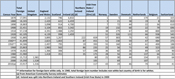
Charts and Graphs
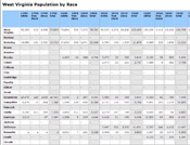 | West Virginia Census by County and Race, 1790-2010 Excel |
 | West Virginia Women Occupations Census, 1880-1960 Excel |
 | West Virginia's Foreign Born by County, 1870-1900 |
|
| West Virginia's Foreign Born by County, 1910-1940 Excel |
 | West Virginia's Foreign Born Population (State Level), 1870-2010 Excel |
 | West Virginia Births and Deaths, 1950-2006 |
 | West Virginia Population, 1870-2010 |
 | West Virginia Population, 1950-2006 |
 | West Virginia Net Migration, 1950-2006 |
Maps
 | Blank map of West Virginia and surrounding states |
 | Map of West Virginia with surrounding states identified by name |
 | Map of West Virginia with surrounding states identified by name, with key/legend box |

| Map of West Virginia rivers and lakes |
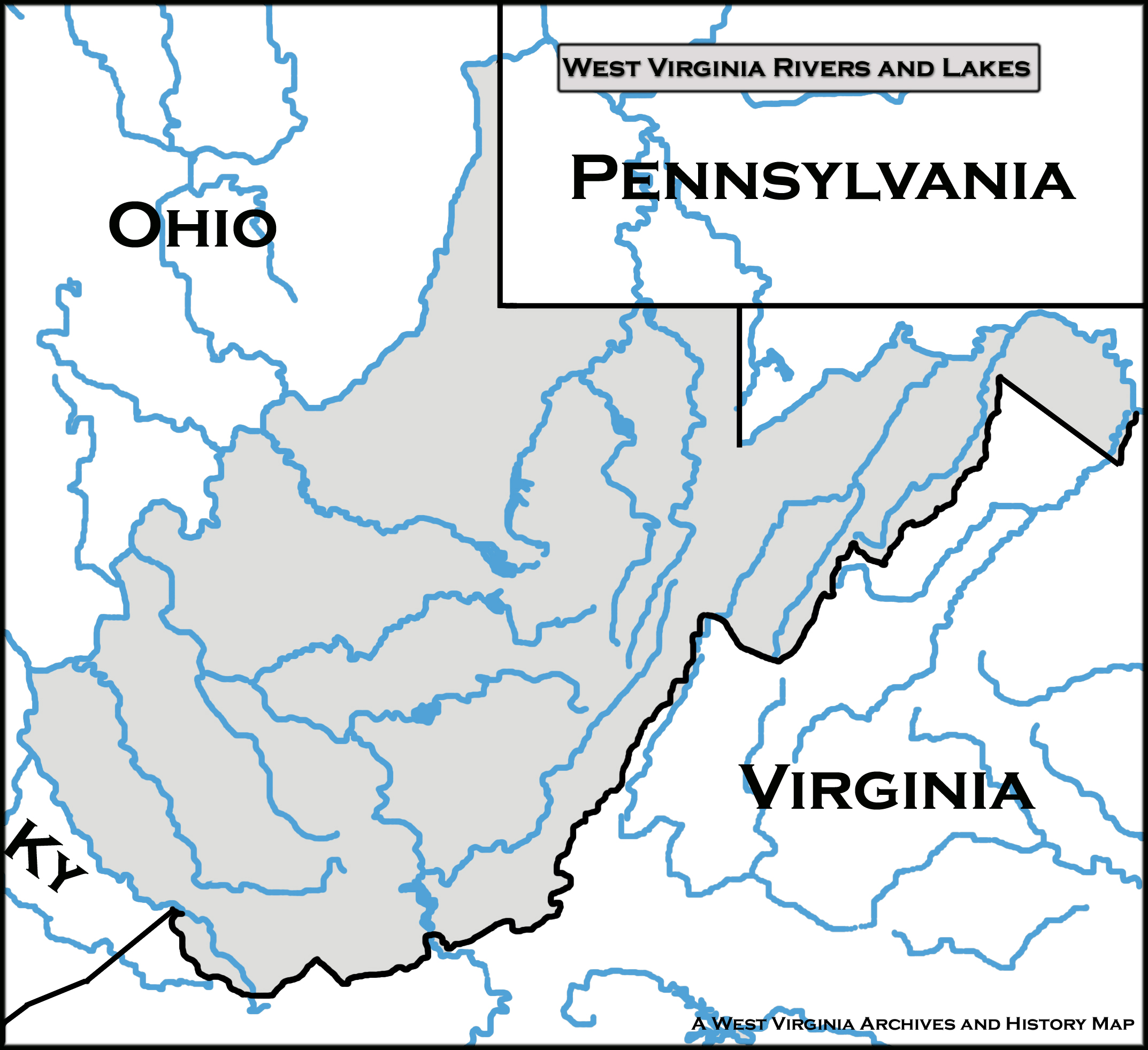 | Map of West Virginia rivers and lakes with surrounding states identified |
 |
 |
 |
 |
 |
| Panhandle map series |
 |
 |
|
 |
 |
 |
 |
 | Economic Regions of West Virginia. West Virginia Development Office. |
 | Outline map of West Virginia counties with county seats. Department of Highways map. |
 | Map of Mid-Atlantic and Midwestern States during the Revolutionary War Era. From George Rogers Clark: His Life and Public Services, by Temple Bodley, 1926. |
 | "Virginia and West Virginia." Published by Phillips and Hunt, [1881]. Ma6-5, Map Collection, West Virginia Archives and History. |
 | "County Map of Virginia and West Virginia," by W. H. Gamble. Published by S. Augustus Mitchell, 1863. Ma5-2, Map Collection, West Virginia Archives and History. |
 | "County Map of Virginia and West Virginia," by W. H. Gamble. Published by S. Augustus Mitchell, 1871. Ma5-5, Map Collection, West Virginia Archives and History. |
 | "A New Map of the State of Virginia exhibiting internal improvements, roads, distances &c," by J. H. Young. Published by Thomas, Cowperthwait and Company, 1850. Ma4-3, Map Collection, West Virginia Archives and History. |
 | "A New Map of Virginia with its Canals, Roads & Distances from place to place, along the Stage & Steam Boat Routes." Published by S. Augustus Mitchell, [between 1845 and 1848]. Ma1-5, Map Collection, West Virginia Archives and History. |
 | "A Correct Map of Virginia." Detached from Mathew Carey and Son, General Atlas, 1818. Ma2-5, Map Collection, West Virginia Archives and History. |
 | "A New Map of Virginia with its Canals, Roads & Distances from place to place, along the Stage & Steam Boat Routes." Published by Thomas, Cowperthwait and Company, 1853. Ma4-4, Map Collection, West Virginia Archives and History. |
 | "Virginia and West Virginia." Detached from Rand, McNally & Company, Indexed Atlas of the World, [1882]. Ma6-4, Map Collection, West Virginia Archives and History. |
 | "Colton's Map of the State of West Virginia and parts of adjoining States." Published by J. H. Colton, 1865. Ma67-2, Map Collection, West Virginia Archives and History. |
 | "Map of the State of Virginia containing the counties, principal towns, railroads, rivers, canals, and all other Internal Improvements." Published by Ritchie and Dunnavant, 1858. Ma67-7, Map Collection, West Virginia Archives and History. |
Photographs
 |
 |
 |
 |
 |